
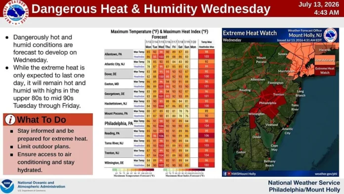

New Jersey is heading into one of the more genuinely dangerous stretches of summer weather the state has seen in recent memory, with heat advisories and extreme heat warnings now issued statewide as feels like temperatures track toward a punishing range between 100 and 109 degrees. Current conditions remain relatively mild by comparison, with partly sunny skies, an average temperature near 80 degrees, humidity sitting at 64 percent, and gentle southwest winds moving at around 9 miles per hour. That relative calm will not last long. A Heat Advisory takes effect today, followed by a considerably more serious Extreme Heat Warning on Wednesday specifically for central and coastal counties, as rising temperatures combine with high humidity to create genuine safety risk for anyone spending extended time outdoors. The strain on the region’s infrastructure is already visible as well, with PJM, the regional power grid operator, placing utility crews on a hot weather alert in anticipation of sharply increased electricity demand as air conditioning use spikes across the state.
New Jersey 7-Day Forecast
| Day | Sky Condition | Temperature | Chance of Rain |
|---|---|---|---|
| Tue, Jul 14 | 93°F / 69°F | 5% | |
| Wed, Jul 15 | 97°F / 73°F | 5% | |
| Thu, Jul 16 | 94°F / 69°F | 25% | |
| Fri, Jul 17 | 89°F / 70°F | 10% | |
| Sat, Jul 18 | 80°F / 71°F | 75% | |
| Sun, Jul 19 | 89°F / 72°F | 35% | |
| Mon, Jul 20 | 90°F / 74°F | 10% |
Important Weather Notes
- The Peak of the Heat (Wednesday): Wednesday will be oppressive. Ambient highs will reach 97°F, but high humidity will push heat indices past 100°F–105°F+ across the state. Limit time outdoors and stay hydrated.
- Midweek Front: A cold front will pass through late Wednesday night. This will break the worst of the heat for Thursday and Friday, bringing temperatures down into the more manageable upper 80s and low 90s.
- Unsettled Weekend: A slow-moving system moves in on Saturday, dropping temperatures to 80°F but bringing a heavy 75% chance of rain and widespread thunderstorms that could lead to localized flash flooding.
Looking at the week ahead, Tuesday, July 14 brings sunny skies with highs near 93 degrees and lows dropping to 69, with only a slim 5 percent chance of rain. Wednesday, July 15 marks the peak of the entire stretch, with partly sunny skies, highs reaching 97 degrees, and lows near 73, again carrying just a 5 percent rain chance despite the oppressive heat. Thursday, July 16 offers a modest step back, with light rain possible, highs near 94, and lows around 69, alongside a 25 percent chance of precipitation. Friday, July 17 continues that gradual cooling trend, with partly sunny skies, highs near 89, lows around 70, and a 10 percent rain chance. The weekend brings a genuinely significant shift in the pattern, with Saturday, July 18 turning unsettled entirely, dropping to a high of just 80 degrees but carrying a heavy 75 percent chance of rain. Sunday, July 19 continues that unsettled theme with scattered thunderstorms, a high near 89, a low around 72, and a 35 percent rain chance, before Monday, July 20 returns to a more typical summer pattern with partly sunny skies, a high of 90, a low of 74, and just a 10 percent chance of rain.
Wednesday stands out as the single most dangerous day of the entire stretch. While the ambient high is expected to reach 97 degrees, the combination of that heat with high humidity will push the actual heat index well past 100 degrees, potentially climbing into the 105 degree range or higher across parts of the state. Anyone spending time outdoors on Wednesday should genuinely limit their exposure and prioritize staying hydrated throughout the day, since heat index values in that range carry real risk of heat exhaustion and heat stroke, particularly for children, older adults, and anyone working outdoors. Relief does arrive shortly after that peak, as a cold front is expected to pass through late Wednesday night, breaking the worst of the heat and bringing Thursday and Friday temperatures back down into the more manageable upper 80s and low 90s. That relief proves short lived, though, as a slow moving weather system arrives Saturday, dropping temperatures to around 80 degrees but bringing a considerably higher 75 percent chance of rain and widespread thunderstorm activity across the region.
The broader atmospheric pattern driving this entire stretch traces back to a ridge of high pressure setting up over the northern Plains and the Dakotas this week. That ridge positions the upper level atmospheric flow directly over the Great Lakes and toward New Jersey and much of the northern Mid Atlantic and New England, a setup that tends to lock in exactly this kind of prolonged heat and humidity. That pattern is expected to hold firmly in place until a weak trough attempts to backfill into the eastern United States late Saturday night into Sunday, effectively acting as the cold front and storm system responsible for breaking the heat heading into the weekend. Forecasters are watching closely for any storm activity that might develop along what’s sometimes referred to as the ring of fire storm corridor earlier in the week, though the stormiest days of the entire stretch currently look to be concentrated in the Friday through Saturday window, with Sunday offering a genuine, if brief, reprieve from both the heat and the humidity. Otherwise, heat and humidity are expected to dominate the region right up until those weekend storms finally arrive to begin breaking the pattern down. Unfortunately, that relief looks likely to last only a day or two before the same hot, humid pattern appears poised to reload again heading into the following week.
Breaking the week down day by day, Monday, July 13 saw high temperatures max out in the 80s under mostly sunny skies with manageable humidity, light winds out of the south, and overnight lows falling back into the comfortable 60s, giving the state one more genuinely pleasant midsummer night before the heat began building in earnest. Tuesday, July 14 pushes highs into the mid to upper 90s across most of New Jersey away from the immediate coastline, with coastal areas holding closer to 90 degrees thanks to typical ocean moderation, under mixed skies leaning more sunny than cloudy and a genuinely humid feel throughout the day, with light winds out of the southwest and overnight lows staying just above 70 statewide.
Wednesday, July 15 brings the week’s most extreme conditions, with high temperatures reaching or slightly exceeding 100 degrees across many New Jersey locations, particularly across central and southern New Jersey away from the coast and closer to the Philadelphia to Trenton stretch along the I-95 corridor. Coastal areas will see somewhat more moderate conditions, still pushing well into the 90s, under mixed skies with a persistently humid feel and winds running light to breezy out of the west and southwest. Overnight lows will again hold just above 70 degrees statewide, with only the higher elevations of northern New Jersey potentially dipping into the upper 60s.
Thursday, July 16 offers genuine, if modest, relief, with high temperatures reaching into the 90s across most of the state, noticeably less intense than the Tuesday through Wednesday peak but still genuinely hot and humid, under mixed skies with light winds out of the west and southwest, and overnight lows falling into the 60 to 70 degree range from north to south. Friday, July 17 continues that gradual cooldown, with highs reaching around 90 degrees or just above for many locations, starting the day with more sun than clouds before afternoon and evening thunderstorms become possible, alongside light winds out of the west and northwest that could turn slightly breezier across southern New Jersey. Overnight lows Friday night should fall into the 65 to 73 degree range, with isolated thunderstorm activity possible continuing into Saturday morning.
Looking ahead to the weekend of July 18 and 19, forecasters are anticipating more 90 degree heat paired with genuinely unsettled thunderstorm activity, though Sunday specifically looks considerably less humid than Saturday, offering residents a real sense of relief after what promises to be a genuinely brutal week of sustained heat and oppressive humidity across the entire state.
















