
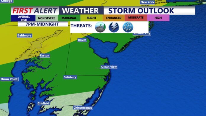

Saturday brings the most active severe weather day of the week, with watches covering both northern and southern New Jersey and a warning already fired off in South Jersey, all while the state stays locked in a run of oppressive heat and humidity that will linger well into next week.
New Jersey’s Muggy, Stormy Stretch Isn’t Done Yet, and Today Brings the Sharpest Threat
Saturday has turned into the most volatile weather day New Jersey has seen this week. With the atmosphere primed by several straight days of intense heat and humidity, the National Weather Service issued back to back severe thunderstorm watches covering opposite ends of the state Saturday afternoon, while a severe thunderstorm warning already fired for parts of Atlantic County as a line of storms raced east at 40 miles per hour, packing wind gusts up to 60 miles per hour capable of damaging roofs, siding, trees, and power lines.
Forecasters have warned that today’s storms could gain extra fuel from the same intense heat and high humidity that has defined the pattern all week, with some cells capable of dropping rain at a rate of two to three inches an hour. That kind of downpour raises real concern for flash flooding, particularly in urban areas and along creeks and streams, where the National Weather Service’s regional office has specifically warned that rapid flooding is possible even outside the storms’ immediate path.
A Pattern Driven by Heat and Humidity, Not Any Single Storm System
What’s notable about this stretch is what is not driving it. There is no major upper level storm system or dramatic weather maker parked over the region. Instead, a Bermuda High sitting off the Atlantic coast has been steering a steady stream of hot, humid air into New Jersey, and the atmosphere has responded with repeated rounds of afternoon and evening thunderstorms as that heat and moisture builds each day and then releases. Temperatures alone have not been especially extreme by August standards, generally running from the high 80s into the low 90s, but dew points sitting above 70 degrees have pushed heat indices to or above 100 on multiple days this week, and today is no exception.
That combination, uncomfortable rather than record breaking heat paired with genuinely oppressive humidity, is expected to persist through at least Tuesday of next week. Sunday looks mostly clear across the state but no less muggy, with highs climbing into the low 90s and heat indices once again pushing past the 100 degree mark. Monday continues the same pattern with mostly cloudy, humid conditions, before a more unsettled stretch moves in Tuesday afternoon into Wednesday, which forecasters expect to finally begin breaking the heat and humidity.
Sunday, Aug. 9
Mostly sunny and humid. High near 90 to the low 90s. Heat index near or above 100.
Monday, Aug. 10
Mostly cloudy, still humid. High near 91. Muggy overnight lows in the low 70s.
Tuesday, Aug. 11
Scattered thunderstorms return. High near 89 with a good chance of rain by afternoon.
When Relief Actually Arrives
Looking further out, the pattern does appear ready to break, at least temporarily. Forecasters expect the unsettled period arriving Tuesday afternoon into Wednesday to usher in a period of relief for Thursday and into next weekend, with temperatures and humidity both easing back from the oppressive levels the state has dealt with for much of the past week. That relief looks to be short lived, however, with early indications pointing to heat and humidity building back into the region again once that brief cooler, drier stretch passes.
For today specifically, the practical guidance is straightforward. Anyone in the northern watch area should stay weather aware through 8 p.m., and anyone in the southern and central watch area should do the same through 6 p.m., with the broader regional watch extending across the wider Northeast corridor until 8 p.m. as well. Storms have already proven capable of producing damaging winds and localized flash flooding today, and given how quickly cells have been intensifying in the current pattern, conditions can shift from a routine summer thunderstorm to a genuine severe weather threat with little advance notice.
Hourly Forecast (Tonight)
| Hour | Sky Condition | Temperature | Chance of Rain |
|---|---|---|---|
| 6 PM | 86°F | 15% | |
| 7 PM | 84°F | 20% | |
| 8 PM | 81°F | 5% | |
| 9 PM | 79°F | 0% | |
| 10 PM | 78°F | 5% | |
| 11 PM | 77°F | 0% |
















