

New Jersey gets one genuinely comfortable day before humidity, storms, and a rising rip current threat move back in Sunday, all while forecasters keep a close eye on a Cape Verde system that could become the season’s next named storm.
A Perfect Saturday, a Stormy Sunday, and the Tropical System Worth Watching This Week
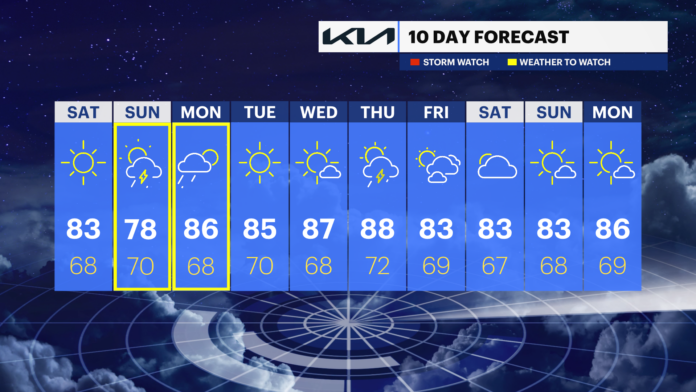
New Jersey gets a genuine, if brief, break from the heat and humidity today, driven by a short lived kink in the upper level jet stream pushing a north to northwest flow across the state. The catch is that this relief may only last through Saturday itself before a more active pattern moves back in for the second half of the weekend.
Friday, Aug 14
Sun, clouds, wildfire haze
Saturday, Aug 15
Mostly sunny, low humidity
Sunday, Aug 16
PM storms, flash flood risk
Monday, Aug 17
Morning showers, drying PM
Tuesday, Aug 18
Dry, stable, sunny
Today’s the Day to Get Outside
Saturday brings low to mid 80s statewide under mostly sunny skies, with a light breeze out of the north or northeast keeping humidity noticeably in check for most of the state. Away from the immediate coastline, dew points should drop below 65 degrees and, in spots further inland and at higher elevation in North Jersey, below 60, making for a genuinely pleasant day outdoors. Overnight lows should settle into the mid 50s to mid 60s range statewide.
Coastal Monmouth, Ocean, southeast Burlington, Atlantic, and Cape May counties should expect a different feel, since ocean temperatures are running near their warmest point of the year, close to 80 degrees, keeping dew points elevated above that 65 degree comfort threshold right along the shore even as inland areas feel considerably drier. That marine warmth is also likely to produce dense overnight and early morning fog wherever the warm ocean air runs into cooler air pushing in from inland, a pattern coastal residents in those counties should watch for heading into Sunday morning.
Sunday Brings the Storms Back
Sunday marks a real shift in the pattern. Humidity and cloud cover increase through the day as a low pressure center drifts over New Jersey during the afternoon and evening, a setup capable of enhancing atmospheric lift and generating enough wind shear that Sunday could turn out stormier than the forecast alone suggests. Showers and thunderstorms become widespread by afternoon into evening, with highs topping out around 80 to 82 degrees. The Weather Prediction Center has identified the highest risk of heavy rainfall rates and localized flash flooding across central and western New Jersey specifically, while some minor urban and low lying drainage flooding remains possible wherever the heaviest downpours happen to stall over one spot for an extended stretch. Isolated storms could also produce locally damaging wind gusts, even as most of the state sees a more routine mix of rain, wind, and rumbles of thunder.
Beachgoers heading to the Shore Sunday should plan around a meaningfully elevated ocean hazard. Rip current risk climbs from low on Saturday to moderate through the day Sunday before reaching high risk late in the afternoon and evening, driven by those strengthening southerly winds and breaking waves building toward 4 to 5 feet, conditions the National Weather Service considers capable of producing life threatening rip currents even for strong swimmers.
A Brief Return to Instability Before Real Relief Arrives
The slow moving Sunday system lingers into Monday morning, with a continuing chance of showers and scattered thunderstorms before drier air begins filtering in later in the day and highs rebound into the upper 80s. Tuesday brings a genuinely clean break, with the state drying out completely under stable, mostly sunny skies and highs settling into the mid 80s. Humidity should hover in a manageable to slightly uncomfortable range through the rest of next week before a considerably more potent air mass, carrying both lower temperatures and lower dew points, moves in behind a cold front expected Thursday into Friday, a stretch of relief that could last several days rather than the single day New Jersey gets this weekend.
By the time August winds down, New Jersey should see an even longer stretch of that same cooler, drier pattern, consistent with how the state’s climate typically behaves in the back half of the month. Warm season weather does not end all at once, and residents should not put away the shorts and short sleeves just yet, since New Jersey has a real track record of producing unexpected heat even after the calendar officially declares summer over on September 22nd, occasionally stretching well into October.
Eyes on the Tropics
Tropical Storm Cristobal formed and dissipated well out to sea in the northern Atlantic without any relevance to the East Coast, and attention has now shifted to a new area of interest the National Hurricane Center is tracking as Invest 94L, an official Cape Verde system. Should it organize into at least a tropical storm, the next name on this year’s list is Dolly. Model consensus currently points toward 94L tracking from its current position north of South America toward, or just northeast of, the northeastern Caribbean islands, where the Lesser Antilles meet the Greater Antilles.
That particular track is worth genuine attention for two reasons. It would largely avoid the kind of disruption Hispaniola’s mountainous terrain typically inflicts on tropical systems passing directly over the island, and a track threading north of the islands typically produces either a direct US impact or a close call somewhere between the East Coast and Bermuda. Should the system intensify into a hurricane while sliding just northeast of the Caribbean, its eventual path will hinge heavily on wind shear and steering currents, potentially the eastern edge of an approaching trough or cold front, to help pull it safely out to sea. If a ridge of high pressure were instead to block that northward and eastward recurve, the system could track toward the East Coast as a landfalling hurricane. There is no reason for New Jersey residents to be alarmed at this stage, but the system is worth watching as it approaches the northeastern Caribbean around Tuesday, with forecasters hoping increased wind shear weakens it before any recurve toward the western Atlantic begins by around next Thursday. A second Cape Verde system trailing behind 94L is also on forecasters’ radar for the days ahead.
















