
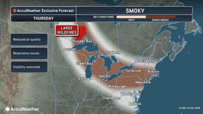

New Jersey is dealing with a genuinely unhealthy air quality situation today, even as the weather itself stays relatively mild, with temperatures sitting around 82 degrees under mostly cloudy skies. A statewide Air Quality Alert, rated Code Red, remains in effect until midnight, driven by thick, hazy smoke drifting down from wildfires burning in Canada. Health officials are urging residents, particularly children, older adults, and anyone with existing respiratory conditions, to limit prolonged time outdoors while that smoke continues settling over the region.
The Canadian smoke haze is expected to linger through Friday, but a shifting weather front on Saturday will bring strong thunderstorms and heavy rain to help clear the air.
| Day | Sky Condition | Temperature | Chance of Rain |
|---|---|---|---|
| Fri, Jul 17 | 87°F / 68°F | 10% | |
| Sat, Jul 18 | 78°F / 71°F | 70% | |
| Sun, Jul 19 | 83°F / 59°F | 0% | |
| Mon, Jul 20 | 82°F / 62°F | 20% | |
| Tue, Jul 21 | 86°F / 72°F | 40% | |
| Wed, Jul 22 | 87°F / 62°F | 75% | |
| Thu, Jul 23 | 81°F / 59°F | 0% |
Upcoming Weekend Outlook
- Saturday Storm Warning: Saturday will feel highly tropical and humid with dewpoints climbing into the 70s. Expect scattered downpours and potentially severe thunderstorms tracking gusts up to 60 mph and frequent lightning. The heaviest rain bands are anticipated during the morning and late evening, bringing an elevated risk for localized flash flooding.
- Sunday Relief: The storm system will completely blow out the wildfire smoke by Saturday afternoon. Sunday will bring beautiful, clear conditions with a comfortable high of 83°F, lower humidity, and a refreshing northwest breeze moving at 11 mph.
That haze is expected to persist through Friday before a shifting weather pattern finally clears the air. Friday itself should bring partly sunny skies mixed with lingering wildfire haze, with highs reaching 87 degrees and lows near 68, along with just a 10 percent chance of rain. The real change arrives Saturday, when heavy thunderstorms move through, dropping highs to 78 degrees with lows around 71 and a 70 percent chance of rain. Sunday brings genuine relief, with clear, sunny skies, a high of 83, a low of 59, and no rain expected at all. Monday returns to a more typical partly sunny pattern with highs near 82 and a 20 percent rain chance, before Tuesday brings scattered light rain with highs around 86 and a 40 percent chance of precipitation. Wednesday turns considerably wetter, with heavy rain expected, a high of 87, a low of 62, and a 75 percent chance of rain, before Thursday closes out the stretch with clear, sunny skies, a high of 81, and a low of 59.
Saturday stands out as the more genuinely active weather day of the entire stretch. Conditions will feel distinctly tropical and humid, with dew points climbing into the 70s, setting the stage for scattered downpours and potentially severe thunderstorms capable of producing wind gusts up to 60 miles per hour along with frequent lightning. The heaviest rain bands are expected during the morning and again late in the evening, raising a genuine risk of localized flash flooding in low lying areas. That storm system, though, comes with a real silver lining, since it’s expected to completely clear out the lingering wildfire smoke by Saturday afternoon, setting up Sunday as a genuinely beautiful day, with clear conditions, a comfortable high near 83, noticeably lower humidity, and a refreshing northwest breeze moving at around 11 miles per hour.
Today itself has already pushed many New Jersey locations past the 90 degree mark, with the rest of the state sitting in the mid to upper 80s, all under skies hazy from the upstream Canadian wildfires. That haze is expected to peak in intensity tonight into tomorrow before conditions begin improving. Forecasters are also watching for the possibility of a similar linear band of downpours and thunderstorms to the one that moved through northern and central New Jersey yesterday, potentially forming again this evening across central into southern New Jersey. Like yesterday’s system, any such band would likely form and dissipate within roughly a two hour window as it moves from north to south. As that boundary pushes through, acting essentially as a cold front, humidity should drop noticeably behind it, though the storms themselves could still produce moderate wind gusts capable of minor damage along with heavy, high volume downpours packed into a short period of time.
The broader pattern driving this weekend’s weather traces back to the upper level jet stream dipping south into New Jersey and the Mid-Atlantic, riding along the backside of a positive tilted trough sitting over southeastern Canada and New England. That dip in the jet stream is what will cool temperatures down while simultaneously increasing rain and storm potential, especially through most of Saturday. Sunday is shaping up as the genuine clear out day, with conditions improving steadily after an unsettled start to the weekend. A cold front pushing through behind that system should drop overnight lows into the 50s for many areas heading into Sunday night and Monday.
Looking further ahead, New Jersey is approaching the more active stretch of hurricane season, though the tropics have remained genuinely quiet so far this year. A significant amount of Saharan dust has been streaming across the Atlantic via easterly winds, and wind shear profiles have remained largely uncooperative for tropical development, a pattern considered fairly typical during a strong El Niño. That combination has kept the Atlantic hurricane basin quiet through the early part of the season, though that’s expected to change before long, particularly once the calendar turns into August.
Breaking the weekend down day by day, Friday’s high temperatures should reach the mid to upper 80s across most of New Jersey, with a few spots away from the coast in central and southern New Jersey potentially pushing just over 90. Skies should stay mostly sunny, though some wildfire haze will likely linger until conditions improve Friday night, with noticeably lower humidity and light winds out of the northwest. Overnight lows should range from the 60s across northern New Jersey’s higher elevations to the mid 70s along the southern coast, and an isolated shower or two can’t be entirely ruled out heading into Saturday morning.
Saturday’s highs should reach the 80 to 85 degree range across most of the state, with humidity building back in considerably. Skies will turn cloudy with periods of rain and thunderstorms likely throughout the day, though a steady, all day downpour seems unlikely. Instead, expect on and off downpours at various points throughout the day, with some thunderstorms capable of producing damaging wind gusts and flash flooding. Winds should stay light to breezy out of the south generally, with stronger gusts possible under or near any individual thunderstorm cell. Overnight lows should fall into the 70 to 75 degree range, with additional showers and thunderstorms possible continuing into early Sunday morning.
Sunday’s highs should reach the low to mid 80s across most of New Jersey. Skies should gradually improve throughout the day, though a few lingering showers or thunderstorms could still be around early on. Winds should stay light to breezy out of the northwest as the cold front finally pushes through, dropping overnight lows into a range from the mid 50s to upper 60s along with considerably lower humidity.
Looking ahead to next week, spanning July 20 through 24, conditions look to settle into a seasonably average pattern, with highs in the low to mid 80s and lows generally in the 60 to 65 degree range. Tuesday and Wednesday look to carry some rain and storm chances, but Monday, Thursday, and Friday all look genuinely pleasant, a stretch of good weather that should extend right into the following weekend as well.
















