
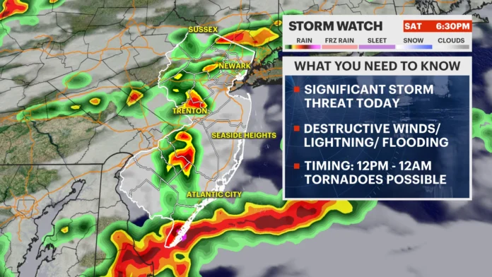

New Jersey is under multiple active weather advisories today, Saturday, July 18, 2026, as the state contends with a genuine dual threat, lingering poor air quality alongside a serious risk of severe afternoon thunderstorms. A Code Orange Air Quality Alert remains in effect statewide due to persistent Canadian wildfire smoke, even as current conditions sit at a relatively mild 74 degrees under cloudy skies with humidity at 86 percent. Layered on top of that air quality concern, a First Alert and Flood Watch has been issued, with heavy downpours, flash flooding, damaging wind gusts up to 60 miles per hour, and isolated tornadoes all considered genuinely possible starting later this afternoon.
New Jersey is under multiple weather advisories today, Saturday, July 18, 2026, due to a dual threat of poor air quality and impending severe afternoon thunderstorms.
A Code Orange Air Quality Alert is currently active across the state due to lingering Canadian wildfire smoke. Conditions are currently cloudy at 74°F with 86% humidity. However, a First Alert / Flood Watch has been issued. Heavy downpours, flash flooding, damaging wind gusts up to 60 mph, and isolated tornadoes are highly possible starting late this afternoon.
Hourly Weather Forecast
| Hour | Sky Condition | Temperature | Chance of Rain |
|---|---|---|---|
| 12:00 PM | 74°F | 0% | |
| 1:00 PM | 75°F | 0% | |
| 2:00 PM | 76°F | 0% | |
| 3:00 PM | 77°F | 0% | |
| 4:00 PM | 78°F | 0% | |
| 5:00 PM | 79°F | 48% | |
| 6:00 PM | 79°F | 51% | |
| 7:00 PM | 78°F | 47% | |
| 8:00 PM | 76°F | 48% | |
| 9:00 PM – Midnight | 75°F – 73°F | 20% |
3-Day Outlook
- Sunday, July 19:
Sunny Sunny and much clearer. High 83°F / Low 60°F. Winds NW at 10 mph. Air quality is expected to significantly improve.
- Monday, July 20:
Sunny Mostly Sunny. High 83°F / Low 63°F. Beautiful start to the workweek.
- Tuesday, July 21:
Heavy thunderstorms Heavy Thunderstorms. High 83°F / Low 69°F. Wet weather patterns return with a 70% chance of rain.
Looking at the hour by hour breakdown, conditions should remain cloudy and dry through the early afternoon, with temperatures climbing gradually from 74 degrees at noon to 78 degrees by 4 p.m. and no measurable rain chance during that stretch. The real shift begins around 5 p.m., when heavy rain showers arrive with a 48 percent chance of precipitation and a temperature of 79 degrees. That activity intensifies into heavy rain and storms from 6 through 8 p.m., with rain chances holding between 47 and 51 percent and temperatures gradually cooling from 79 down to 76 degrees. The activity should begin tapering into lighter rain between 9 p.m. and midnight, with temperatures easing from 75 down to 73 degrees and rain chances dropping to around 20 percent as the system finally works its way through.
Relief arrives quickly behind that system. Sunday, July 19 should bring sunny skies and much clearer conditions overall, with a high of 83 degrees and a low of 60, light winds out of the northwest around 10 miles per hour, and a significant improvement in air quality as the wildfire smoke finally clears out. Monday, July 20 continues that pleasant stretch with mostly sunny skies, a high of 83, and a low of 63, giving the state a genuinely beautiful start to the workweek. That relief proves short lived, though, as Tuesday, July 21 brings heavy thunderstorms back into the picture, with a high of 83, a low of 69, and a 70 percent chance of rain as another wet weather pattern moves in.
Meteorologists tracking today’s severe weather setup have identified a genuinely complete environment capable of producing damaging thunderstorms, combining several key ingredients at once. The atmosphere is sitting at the bottom of a swinging trough, benefiting from strong diurnal destabilization as the day heats up, supported by adequate wind shear, a solid lifting trigger in the form of an approaching frontal boundary, and sufficient atmospheric moisture to fuel genuine storm development. All of those ingredients together point toward a real possibility of newsworthy storm damage across New Jersey by Saturday night into early Sunday morning. What remains genuinely uncertain is exactly how much the lingering smoke layer overhead might interfere with storm formation, along with how much atmospheric energy gets used up by any initial morning shower and storm activity across northern and central New Jersey, both factors that could meaningfully shift how the rest of the day actually plays out.
Despite that uncertainty, forecasters remain confident that most of the state will see rain at least a few times today, though this is not shaping up to be an all day washout. Southern New Jersey in particular looks likely to stay dry until sometime after noon, possibly not seeing rain until late afternoon or early evening. The overall pattern looks to unfold as a series of linear storm fronts moving through from northwest to southeast, which typically means shorter bursts of heavy rain and storms separated by genuine lulls in between, rather than one continuous, sustained severe weather event blanketing the entire state at once. This is considerably closer to a scenario where everyone experiences rain and a moderate breeze, while only some areas end up experiencing the most severe conditions, rather than a blanket severe weather threat hitting the whole state equally.
Breaking down the expected timeline further, an initial round of showers and thunderstorms is expected to move through northern New Jersey and possibly parts of central New Jersey earlier in the day. From there, forecasters are watching for a series of one to three separate storm fronts to push through the state from northwest to southeast between the afternoon hours and early Sunday morning. Nearly everyone in the state should expect at least a downpour or two accompanied by frequent lightning, while more localized pockets of activity could bring genuinely damaging straight line winds, larger hail, possible tornadoes, and several additional inches of rainfall on top of what’s already fallen. A cold front is expected to finally clear all of that activity out by early Sunday morning, setting up a genuinely gorgeous Sunday stretching into Sunday evening, before that pleasant pattern extends into Monday and the state heads back into another round of rain and storm potential by midweek.
In plain terms, today carries real risk that deserves genuine attention and preparation. Much of southern and central New Jersey may not see rain until later in the afternoon or early evening, while northern New Jersey could see some activity earlier in the day, activity that might actually reduce how much additional storm energy remains available for that region later on, leaving central and southern New Jersey to bear the brunt of the afternoon and evening threat instead. Wherever the linear storm fronts do pass through, residents should expect at least rain and a moderate breeze statewide, but in more localized spots, the real dangers include flash flooding from intense downpours, hail exceeding an inch in diameter, frequent lightning, and damaging winds capable of anything from scattering loose outdoor furniture to causing genuine structural roof damage. Given that range of potential outcomes, it’s worth taking sensible precautions now, securing loose outdoor items and having a plan in place to get children and other vulnerable family members to a safe, sturdy location if warnings are issued later today. Conditions should improve dramatically behind tonight’s cold front, with Sunday emerging as a genuinely refreshing, storm free day as both the severe weather and the lingering wildfire smoke finally clear out to sea together.
















