
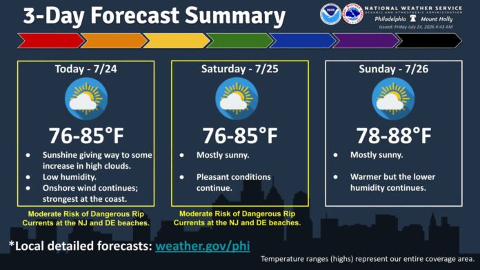

New Jersey is currently basking in what local meteorologists are calling one of the best mid-summer weather stretches in recent memory, with sunny skies, a comfortable 71 degrees, and humidity sitting at a genuinely pleasant 66 percent as of today. A light 4 mile-per-hour breeze out of the north and a low UV index of 2 round out conditions that should stay mostly sunny through the afternoon before skies turn overcast later tonight, setting the stage for what promises to be a genuinely stellar weekend ahead.
New Jersey 7-Day Weather Forecast
| Day | Sky Condition | Temperature | Chance of Rain |
|---|---|---|---|
| Fri, Jul 24 | 80°F / 60°F | 10% | |
| Sat, Jul 25 | 78°F / 57°F | 0% | |
| Sun, Jul 26 | 82°F / 61°F | 0% | |
| Mon, Jul 27 | 84°F / 65°F | 35% | |
| Tue, Jul 28 | 79°F / 68°F | 45% | |
| Wed, Jul 29 | 84°F / 64°F | 40% | |
| Thu, Jul 30 | 83°F / 61°F | 20% |
That shift traces directly back to a cold front that moved through the state yesterday, Wednesday, clearing out a considerable amount of humidity in its wake. This time of year, cold fronts tend to have a far greater impact on reducing humidity than on lowering temperatures outright, and that distinction matters enormously in practice, since dry air in the 80s feels considerably cooler and more comfortable than the same temperature under swampy, saturated conditions. Overnight lows are dropping into the 50s rather than lingering above 70, a genuinely dramatic shift that makes this stretch feel like night and day compared to the muggy conditions the state was dealing with just days ago.
Meteorologists are crediting an upper-level zonal pattern, marked by positive height anomalies sitting over New Jersey, for keeping this stellar weather locked in place through at least Sunday morning, and possibly into Monday. A trough is expected to begin developing over the Mid-Atlantic starting Sunday, setting up a stormier period midweek, but for right now, the region is experiencing the driest-feeling air of this entire pleasant stretch, conditions expected to hold through Saturday before humidity slowly starts ticking back upward on Sunday as that trough begins taking shape.
For anyone hoping to spend an evening looking up at the night sky, the next few nights are shaping up to be genuinely ideal for stargazing. Thursday, Friday, and Saturday nights should all offer excellent viewing conditions, with the moon sitting low enough on the horizon after 10 p.m. to allow for genuinely great views of the mid-summer starry sky without excessive light interference.
Breaking down the days ahead, tonight will dip into the 50s across the state, running slightly warmer in southern New Jersey than the north, with a notably cool, dry, and pleasant feel for late July under clear skies. Friday, July 24 should bring high temperatures in the low to mid-80s across most of the state, with mostly sunny skies and perhaps a few passing clouds in the afternoon that should clear out entirely by sunset. Winds will stay light out of the east and northeast, with overnight lows falling into the 55 to 65 degree range statewide under continued clear skies.
Saturday, July 25 looks similarly excellent, with highs again reaching the low to mid-80s, running slightly warmer away from the coast in the mid-80s and closer to 80 degrees along the shore itself. Skies remain mostly sunny with light winds out of the northeast, and overnight lows again settle into the 55 to 65 degree range under clear conditions. Sunday, July 26 brings highs climbing into the mid to upper 80s away from the coast, with coastal areas topping out closer to 80 or the upper 70s, and a touch more humidity beginning to creep back into the air as the approaching trough starts to develop. Winds shift light out of the west and southwest inland, with a light southeast flow along the coast, and overnight lows settle into the 60 to 65 degree range under mostly clear skies.
Looking ahead to next week, spanning July 27 through 31, temperatures should mainly hold in the 80s statewide, with Monday, Thursday, and Friday shaping up as the sunniest, driest days of that stretch. Tuesday and Wednesday carry the best chances for showers and thunderstorms, though forecasters aren’t expecting an all-day washout on either day. Humidity is expected to gradually tick upward starting Sunday and continuing through Monday, building toward that midweek stormy stretch before conditions presumably improve again heading toward the following weekend.
For now, though, New Jersey residents have a genuinely rare, comfortable stretch of summer weather to enjoy, dry air, cool nights, sunny skies, and clear conditions for stargazing, all courtesy of a cold front that arrived at exactly the right moment to reset what had been a genuinely muggy summer pattern into something considerably more pleasant heading into the weekend.
















