
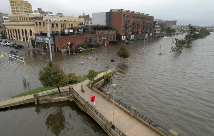

New Jersey endured a genuinely historic flash flood emergency on Saturday, July 18, 2026, as a relentless wave of back to back summer thunderstorms dropped between five and eight inches of rain across parts of the state in a remarkably short window, overwhelming local storm infrastructure and prompting comparisons to the catastrophic damage caused by Hurricane Ida. The scale of the flooding triggered a formal state of emergency across North and Central Jersey, forcing officials to deploy significant emergency resources overnight as roads, homes, and businesses across multiple counties took on serious water damage.
The current weather conditions in Cherry Hill, NJ are sunny and 62°F with a humidity of 78% and light north winds blowing at 4 mph.
The recent, catastrophic flash flood conditions will completely clear up today, giving the region a much-needed break for cleanups before a round of heavy, potentially severe thunderstorms moves back in tomorrow.
📅 Weekly Weather Forecast
| Day | Sky Condition | Temperature | Chance of Rain |
|---|---|---|---|
| Mon, Jul 20 | 84°F / 63°F | 0% | |
| Tue, Jul 21 | 81°F / 70°F | 85% | |
| Wed, Jul 22 | 87°F / 65°F | 45% | |
| Thu, Jul 23 | 81°F / 60°F | 0% | |
| Fri, Jul 24 | 84°F / 62°F | 10% | |
| Sat, Jul 25 | 84°F / 62°F | 0% | |
| Sun, Jul 26 | 85°F / 64°F | 0% |
⚠️ Mid-Week Storm & Flood Risk Details
- Tuesday Inundation: Active storm systems build heavily overnight on Monday, leading to an 85% chance of severe thunderstorms on Tuesday. These systems bring high-humidity air mass and strong winds up to 14 mph.
- Flooding Concerns: Because the ground across North and Central Jersey is entirely saturated from the weekend’s 5 to 8 inches of rain, Tuesday’s heavy downpours introduce a renewed risk of flash flooding. Storm infrastructure may easily back up again.
- Late Week Relief: Wednesday afternoon tapers off with scattered storms. A strong high-pressure front locks in by Thursday morning, clearing the skies completely and dropping the humidity to a comfortable 50% for a beautiful, dry weekend.
The flooding’s impact on the state’s roadway network proved genuinely severe. Torrential rain completely submerged Park Avenue and US-22 in Scotch Plains, stranding dozens of vehicles in chest deep water and trapping drivers inside their cars until rescue crews could reach them. Jersey City experienced its own version of the crisis, as severe drainage failures left major streets entirely underwater, bursting pipes in the process and sending floodwater directly into local businesses along affected corridors. As water levels continued rising, state officials made the decision to fully close stretches of Interstate 287, Interstate 280, Route 440, and Route 9, cutting off major transportation arteries across the region at the height of the storm. The disruption extended into air travel as well, with high volume thunderstorm activity prompting the FAA to issue strict ground stops at Newark Liberty International Airport, pushing average flight delays past three and a half hours as the airport worked through the backlog created by the storm.
In response to the scale of the emergency, local mayors and Governor Mikie Sherrill activated formal emergency response protocols, deploying the National Guard alongside heavy rescue assets to support overwhelmed local first responders. Those responders worked through the night executing dozens of high water vehicle rescues across Bayonne, Elizabeth, Newark, and Woodbridge, pulling stranded drivers from flooded roadways in conditions that grew genuinely dangerous as the storm intensified. Compounding the challenge of tracking the storm in real time, severe lightning strikes knocked out critical weather monitoring equipment, taking the National Weather Service’s Mount Holly radar system completely offline during a stretch when accurate, real time storm tracking mattered most.
As of today, conditions have shifted dramatically for the better, at least temporarily. Cherry Hill is currently reporting sunny skies at 62 degrees, with humidity at 78 percent and light north winds moving at 4 miles per hour, giving the region a genuine, if brief, window to begin cleanup efforts after this weekend’s damage. That relief, however, is not expected to last long.
Looking at the week ahead, Monday, July 20 should stay sunny with a high of 84 degrees, a low of 63, and no measurable chance of rain, giving crews and residents a full clear day to make progress on recovery work. That break ends abruptly on Tuesday, July 21, when heavy thunderstorms return with an 85 percent chance of rain, a high of 81 degrees, and a low of 70. Wednesday, July 22 continues that unsettled pattern with scattered thunderstorms, a high of 87, a low of 65, and a 45 percent rain chance, before Thursday, July 23 clears back to sunny skies with a high of 81 and a low of 60. Friday, July 24 brings mostly cloudy conditions with a high of 84, a low of 62, and just a 10 percent rain chance, while Saturday, July 25 and Sunday, July 26 both look genuinely pleasant, with mostly sunny to sunny skies, highs in the mid 80s, and no measurable rain chance on either day.
Tuesday’s storm system deserves particular attention given the state’s current condition. Active storm systems are expected to build heavily overnight Monday, leading directly into that 85 percent chance of severe thunderstorms Tuesday, driven by a high humidity air mass paired with winds gusting up to 14 miles per hour. Because the ground across North and Central Jersey remains entirely saturated from this past weekend’s five to eight inches of rain, Tuesday’s heavy downpours carry a genuinely renewed risk of flash flooding, since already saturated soil and storm infrastructure that may not have fully recovered from Saturday’s damage could back up again relatively quickly under a fresh round of heavy rain. Residents in the hardest hit areas from this weekend’s flooding should pay particularly close attention to forecasts heading into Tuesday, given how little capacity the ground and drainage systems currently have left to absorb another significant rain event.
Relief does appear to be on the way behind that Tuesday system. Wednesday afternoon should see storm activity taper into more scattered coverage, and a strong area of high pressure is expected to lock in by Thursday morning, clearing skies completely and dropping humidity down to a considerably more comfortable 50 percent, setting up a genuinely beautiful, dry stretch heading into next weekend. For a state still recovering from one of its most significant flash flood emergencies in recent memory, that late week and weekend relief offers a genuine window to complete cleanup and repair work before, hopefully, a more settled stretch of summer weather takes hold.
















