
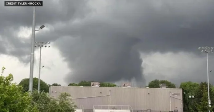

New Jersey is enjoying a genuinely welcome return to calm, clear weather today, Wednesday, July 22, 2026, as the severe storm system responsible for confirmed tornadoes and widespread flash flooding on Tuesday finally pulls entirely out of the region. All active severe weather watches and alerts have officially been dropped statewide, giving residents a real chance to exhale after a genuinely dangerous stretch of weather. While early morning residual fog, mist, and isolated drizzle may still linger across southern counties, conditions are drying out rapidly, with skies expected to clear into prominent stretches of sunshine by this afternoon and humidity levels steadily easing back from the tropical extremes felt over the past several days.
As of mid-morning, the statewide average temperature sits at 77 degrees, with a feels-like reading of 81 given the still-elevated humidity of 85 percent, though that humidity is expected to drop steadily as drier air continues moving into the region. Winds remain out of the southwest at around 10 miles per hour. Looking at the hour by hour breakdown, skies stay sunny through the morning, with temperatures climbing from 78 degrees at 10 a.m. into the low 80s by early afternoon, and only a slim chance of rain lingering through midday. The afternoon brings mostly sunny skies with highs peaking between 86 and 87 degrees from 2 to 5 p.m., before conditions turn fully sunny again from 6 to 8 p.m. as temperatures ease back into the low 80s. The evening closes out clear with periodic clouds, temperatures gradually cooling from 72 to 77 degrees between 9 p.m. and midnight, and just a 5 percent chance of any lingering rain.
Understanding exactly what produced Tuesday’s severe weather helps explain why today feels like such a dramatic turnaround. Tuesday’s storms formed directly along a warm front moving through New Jersey from southwest to northeast, and the atmospheric shift on either side of that front was genuinely striking. Dew point temperatures jumped from the 50s into the 70s in less than 12 hours across most of the state, a rapid surge in atmospheric moisture that set the stage for exactly the kind of severe weather that followed. That warm front carried its own lifting mechanism, essentially hopping over the cooler air sitting ahead of it, and that lifting process was enough on its own to spark an isolated storm cell across northeastern New Jersey even before the main event arrived.
Once that warm front pushed through, the state moved into what meteorologists call the warm sector, the region sitting between the approaching cold front and the warm front that had just passed. That warm sector pulled in genuinely warm, humid air originating from the Gulf, and it was within that sector that Tuesday’s strongest thunderstorms ultimately developed, rotating around a broader low pressure system that had been tracking through the region as part of a classic Norwegian Cyclone Model pattern. The main cluster of storms took time to fully organize and move through the state, with the most intense activity reaching western New Jersey in the late afternoon before finally clearing eastern New Jersey closer to 10 or 11 p.m. that night.
Whether Tuesday’s storms produced primarily heavy rain and lightning or escalated into more genuinely damaging territory, including the straight-line wind gusts and isolated tornadoes that were ultimately confirmed, came down to several specific atmospheric factors that meteorologists were tracking closely in real time. How much direct sunlight reached the ground within the warm sector mattered enormously, since sustained sun exposure heats the surface and destabilizes the lower atmosphere in a way that favors more severe outcomes. Similarly important was how much the day’s earlier, isolated pop-up thunderstorms had already stabilized the atmosphere ahead of the main event, along with how effectively the upper level jet stream vented and sustained the developing storms’ intensity, and how much of a capping inversion had formed in the lower and mid levels of the atmosphere to either suppress or allow that storm development. As it turned out, conditions lined up in a way that allowed Tuesday’s system to produce genuinely serious, confirmed tornado activity alongside the flash flooding that swept across the state.
With that system now fully departed, attention turns toward what remains a genuinely encouraging outlook for the rest of the week and into the weekend. Thursday, July 23 brings sunny skies with a high of 80 degrees, a low of 57, and just a 5 percent chance of rain. Friday, July 24 continues that pleasant pattern with partly sunny skies, a high of 82, a low of 58, and another 5 percent rain chance. Saturday, July 25 looks genuinely ideal, with sunny skies, a high of 80, a low of 57, and no measurable rain chance at all.
Anyone heading to the Jersey Shore in the coming days should still exercise real caution despite the improving weather overall. The New Jersey 101.5 Shore Report has flagged an elevated risk of dangerous rip currents along the coast, with ocean waves cresting up to five feet, a direct consequence of yesterday’s intense storm system having churned up the Atlantic even after the storm itself moved on. A Small Craft Advisory also remains active, with southwest winds still running 15 to 20 knots, conditions that continue to make travel genuinely hazardous for smaller boats even as the skies overhead look increasingly inviting.
Looking further ahead, meteorologists are projecting that a genuinely dry, refreshing area of high pressure will settle firmly over the region by Thursday, setting up what forecasters expect to be one of the cleanest, most comfortable weekends the state has seen all summer. For a state that spent Tuesday dealing with confirmed tornadoes and widespread flash flooding, that kind of calm, low humidity stretch ahead offers a genuinely welcome contrast, and a real chance for residents and cleanup crews alike to catch their breath before whatever comes next in what has already proven to be a genuinely active summer weather pattern.
















