


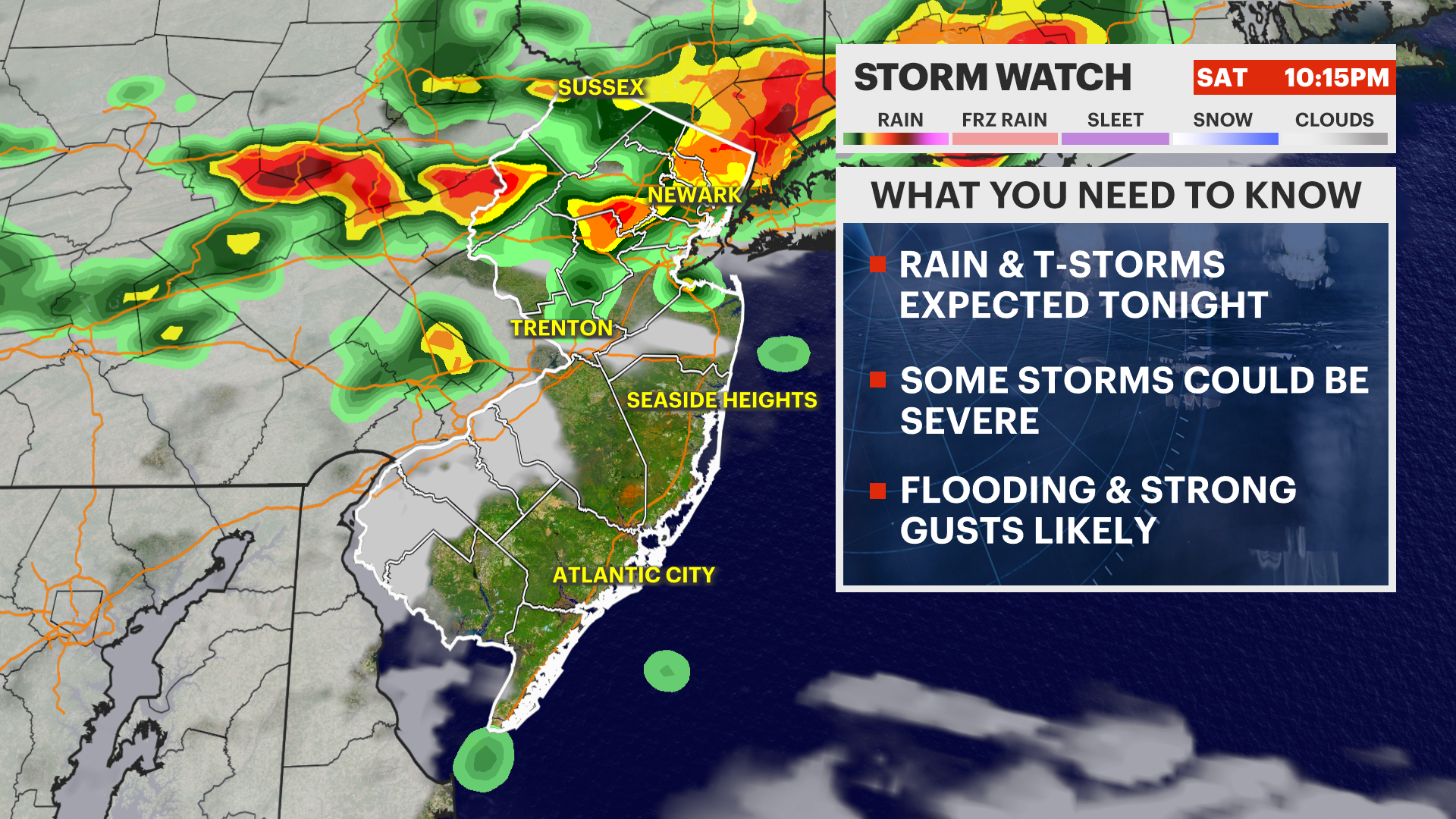
The weather emergency that Governor Mikie Sherrill declared on the Fourth of July has continued to worsen through Saturday, with the state’s death toll from heat-related causes now at 22 suspected fatalities according to the New Jersey Department of Health — three more than the 19 the health commissioner confirmed at Friday’s emergency press conference — and with the storm damage from back-to-back severe systems adding a fatality of a different kind: a person killed by a falling tree in Scotch Plains as 65-mile-per-hour winds tore through Union County overnight and through the early hours of Saturday. At the same moment, the National Weather Service has issued a Flood Watch covering 17 New Jersey counties that remains in effect from noon Saturday through 6 a.m. Tuesday, warning of multiple incoming storm rounds capable of depositing 2 to 3 inches of rainfall across most of the state and up to 5 inches of localized accumulation in Bergen County and portions of the northern counties — a volume, arriving on top of saturated ground and into communities still cleaning up from the previous storms, that carries a serious threat of urban, low-lying, and highway flash flooding across exactly the areas most densely populated with New Jersey residents.
The aggregate emergency now encompasses three overlapping and individually severe conditions simultaneously: a heat event that is, by the governor’s own characterization, the worst the state has experienced in 14 years; a storm damage recovery operation affecting tens of thousands of residents without power; and an incoming severe weather system that will arrive before the recovery from the previous one is complete. A Heat Advisory remains in effect through 8 p.m. Saturday, with heat index values between 100 and 105 degrees across central and southern New Jersey. A Code Orange Air Quality Alert is active for northern and central counties, meaning that children, elderly residents, and anyone with respiratory conditions faces elevated risk simply from ambient air in those areas during outdoor exposure. And the transit infrastructure that New Jersey residents depend on to access cooling centers, reach medical facilities, and navigate their daily lives has been materially damaged by the storm systems in ways that will take days to fully repair.
Four NJ Transit commuter rail lines remain fully suspended in both directions as of Saturday: the Morris and Essex Lines, the Gladstone Branch, the Montclair-Boonton Line, and the North Jersey Coast Line. Overhead wire damage, track debris, and equipment failures resulting from the combination of extreme heat stress and storm-force winds have left tens of thousands of regular riders without rail service during a period when the transit alternatives — driving through storm-damaged road corridors, ridesharing through surge-priced holiday weekend demand — are themselves constrained. Transit crews are working to restore service, but the scope of the overhead wire damage specifically — the infrastructure that powers electric locomotive operations along the affected lines — has made a rapid full restoration timeline impossible to commit to. For the tens of thousands of New Jersey commuters whose work schedules, medical appointments, or basic daily routines depend on these four lines, the suspension represents both an immediate practical disruption and a preview of the Monday morning commute problem that the state will need to address before the regular weekly transit demand cycle resumes.
The storm damage that has produced the power outages and rail disruptions is not merely an infrastructure story. In Scotch Plains, the tree that fell and killed a person overnight represents the specific, sudden violence that storms with 65-mile-per-hour gusts produce in residential communities where mature trees are numerous and the warning window before a gust front arrives can be measured in minutes rather than hours. In River Edge, a residential structure was fully engulfed in flames, though the home was unoccupied and no casualties were reported in that incident. Most dramatically, a lightning strike from one of the overnight storm systems ignited a five-alarm fire at a church somewhere in the state — a fire requiring the full emergency response resources of multiple departments and hours of firefighting to contain. Power outages affecting more than 120,000 residences and businesses across New Jersey, with some municipalities warning that full restoration may not occur until midweek, have prompted towns including Nutley to open emergency cooling centers specifically because the combination of lost air conditioning and continued high temperatures and heat indices creates medically dangerous conditions that require an alternative for affected residents.
New Jersey is currently under an active Heat Advisory and a widespread Flood Watch, facing a volatile mix of triple-digit heat indexes and impending severe, torrential thunderstorms.
Current conditions are cloudy, humid, and 86°F, though high humidity makes it feel like 92°F. While the afternoon will remain mostly cloudy with a stray shower or storm, the national weather service warns that widespread heavy rain and severe storms will move in tonight, carrying a high risk of localized flash flooding and damaging 60+ mph wind gusts.
Hourly Forecast: Sunday, July 5, 2026
| Hour | Sky Condition | Temperature | Feels Like | Chance of Rain |
|---|---|---|---|---|
| 2 PM | 87°F | 93°F | 10% | |
| 4 PM | 87°F | 94°F | 10% | |
| 6 PM | 83°F | 89°F | 15% | |
| 8 PM | 78°F | 82°F | 20% | |
| 10 PM | 75°F | 79°F | 42% | |
| Midnight | 73°F | 77°F | 85% |
10-Day Outlook: The Stormy Shift
| Day | Sky Condition | Temperature (High/Low) | Chance of Rain |
|---|---|---|---|
| Sun, Jul 5 | 87°F / 72°F | 85% (Overnight) | |
| Mon, Jul 6 | 76°F / 67°F | 70% | |
| Tue, Jul 7 | 71°F / 66°F | 45% | |
| Wed, Jul 8 | 80°F / 67°F | 20% | |
| Thu, Jul 9 | 83°F / 69°F | 20% | |
| Fri, Jul 10 | 90°F / 70°F | 35% | |
| Sat, Jul 11 | 81°F / 63°F | 40% | |
| Sun, Jul 12 | 83°F / 60°F | 15% | |
| Mon, Jul 13 | 87°F / 63°F | 20% | |
| Tue, Jul 14 | 90°F / 68°F | 25% |
⚡ Critical Weather Advisories
- Heat Advisory: In effect until 8:00 PM tonight. Heat index values are spiking between 100°F and 105°F across central and southern Jersey. Avoid prolonged outdoor exposure. [1, 2, 3]
- Widespread Flood Watch: In effect from noon today through 6:00 AM Tuesday. Multiple rounds of storms could dump 2 to 3 inches of rain globally, with northern areas like Bergen County bracing for up to 5 local inches. Expect rainfall rates over 2 inches per hour, generating immediate urban, low-lying, and highway flash flooding. [1, 2, 3, 4, 5]
- Air Quality Alert: A Code Orange alert is active for northern/central counties, signaling unhealthy air concentrations for children, the elderly, and those with respiratory conditions. [1]
The current conditions on Saturday afternoon — 86 degrees, actual feels-like temperature of 92, mostly cloudy skies — are deceptively mild relative to the peak of Thursday’s and Friday’s heat event but misleadingly calm relative to what the forecast shows arriving after dark. The hourly progression from Saturday evening through midnight tells the specific story of a pattern in transition: temperatures in the upper 80s through late afternoon with low storm probability, declining into the upper 70s by 10 p.m. as the incoming system approaches, with 42 percent chance of rain at 10 p.m. rising to 85 percent by midnight as the heavy rain and storm activity arrives. The National Weather Service is warning of rainfall rates exceeding 2 inches per hour during the most intense cells — a rate that overwhelms the drainage capacity of New Jersey’s suburban and urban stormwater infrastructure under any conditions, and that arriving into soil that has already absorbed multiple rounds of storm rainfall since Thursday will generate immediate runoff rather than absorption, producing the flash flooding the Flood Watch is specifically designed to warn against.
The 10-day forecast that follows this weekend’s emergency reflects a pattern that does not fully return to anything resembling stability until the middle of next week. Monday brings 70 percent storm probability with a high of 76 — a significant break from the triple-digit heat index conditions that defined the preceding days, but still a wet and unsettled day on which cleanup and restoration work will be hampered. Tuesday’s 45 percent chance of morning showers and Wednesday’s 20 percent probability under mostly cloudy skies represent the closest thing to breathing room available in the near-term forecast window, before another storm cycle develops by Friday and Saturday with shower and thunderstorm probability again reaching 35 to 40 percent. The temperature pattern through mid-July — highs in the 80s and eventually back toward 90 by the 14th — represents a return toward seasonal norms rather than the extreme that has defined this week, but the absence of any extended settled, dry period through at least July 12 means that infrastructure repair, storm debris cleanup, and agricultural recovery from the rain accumulation will proceed in compressed and intermittent windows rather than across uninterrupted good weather.
For New Jersey residents navigating the next 48 hours, the guidance from the state’s emergency management, health, and transportation agencies is consistent and specific. The active Heat Advisory through 8 p.m. Saturday means that outdoor activity during the afternoon hours remains a genuine health risk for vulnerable populations, even though the peak of the heat event has technically passed — the heat index values of 100 to 105 in central and southern Jersey are well within the range that causes heat exhaustion and can escalate to heat stroke in anyone without access to cooling, hydration, and rest. The Flood Watch through Tuesday morning means that any low-lying area, any road that has previously flooded in heavy rain, and any body of water adjacent to residential areas should be treated as a risk to monitor from a safe distance rather than to approach or cross. The Code Orange Air Quality Alert specifically means that children playing outdoors, elderly residents taking walks, and anyone with asthma or another respiratory condition should limit outdoor exposure in northern and central counties for the duration of the alert.
Residents without power should report outages to their utility as soon as possible if they have not already done so, avoid downed power lines under any circumstances, and locate the nearest available cooling center if their home environment is becoming medically unsafe. The state’s heat safety and cooling center resources remain available at nj.gov/heat. NJ Transit passengers on the four suspended lines should monitor NJTransit.com and the NJ Transit app for service restoration updates, understand that bus alternatives may have limited capacity under current conditions, and plan significant additional travel time into any Saturday or Monday commute that would normally rely on the Morris and Essex, Gladstone Branch, Montclair-Boonton, or North Jersey Coast Lines. The holiday weekend that New Jersey’s nine million residents began planning weeks or months ago has been fundamentally transformed by weather conditions that the state’s emergency management infrastructure did not create and cannot fully control, but is actively managing against with the resources available. The number that matters most in any extended accounting of this event is 22 — the suspected heat deaths that have accumulated since Thursday — and the goal of every state agency still deployed through the weekend is to prevent that number from climbing further.
















