
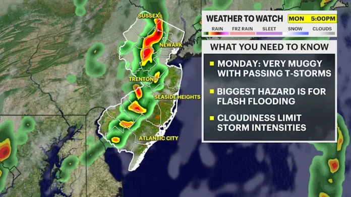

This isn’t a passing summer shower. A saturated atmosphere colliding with a stalled storm system means the entire state is under a Flash Flood Watch Monday afternoon into the night, with rainfall rates capable of overwhelming storm drains in minutes.
A Dangerous, Slow-Moving Storm Is About to Park Itself Over All of New Jersey
This isn’t a passing summer shower. A saturated atmosphere colliding with a stalled storm system means the entire state is under a Flash Flood Watch Monday afternoon into the night, with rainfall rates capable of overwhelming storm drains in minutes.
The National Weather Service has confirmed what the radar’s been hinting at for days. A slow-moving storm system is colliding directly with extreme summer humidity, and the atmosphere is so thoroughly saturated that localized downpours will hit rainfall rates of 2 to 3 inches per hour, more than enough to overwhelm storm drains almost instantly and trigger rapid flash flooding wherever a cell decides to stall. Because the system itself is parking directly over the region rather than moving through quickly, every corner of New Jersey will see heavy rain Monday. The real variable is where individual storm cells repeatedly track, or train, over the same towns, since that’s what turns a rough afternoon into a genuinely dangerous one.
South Jersey & Cherry Hill
General totals of 0.5 to 1.5 inches are likely, but any cell stalling over Camden, Burlington, or Gloucester counties could easily drop 2 to 3-plus inches in a short window.
Watch for major ponding on Route 70, Route 38, and I-295, along with frequent lightning and localized damaging wind gusts.
Central Jersey, I-95 Corridor
Expect torrential rain starting in the morning, a brief midday lull, then a second, more aggressive round firing back up right during the evening commute.
Widespread totals of 1 to 2 inches, with extreme outliers hitting 4 inches in low-lying or poorly drained urban areas. Small streams and urban intersections face the sharpest flash flood risk.
North Jersey, Morristown & Bergen County
Showers and severe storms run through the entire morning and evening. Mountainous terrain across Morris, Hunterdon, Warren, and Bergen counties could squeeze out localized totals topping 3 to 5 inches.
Expect dangerous flash flooding in historically vulnerable low-lying streets, rapid rises in local creeks, and likely barricade deployment from local emergency management teams.
Jersey Shore, AC to Cape May
Widespread drenching downpours arrive alongside a High Rip Current Risk in effect for every New Jersey beach Monday. Nobody should be in the ocean.
Minor coastal flooding is also possible during high tide cycles, adding a second hazard on top of the rain itself.
| Time | Avg Temp | Rain Chance | Peak Hazards |
|---|---|---|---|
| 6:00 AM | 73°F | 80% | Dense fog, steady morning rain, damp roadways |
| 10:00 AM | 77°F | 75% | Humid, steady rain bands moving south to north |
| 1:00 PM | 81°F | 90% | Heavy downpours firing up, low-lying street ponding |
| 4:00 PM | 83°F | 90% | Severe storms, 2 to 3 in/hr torrential rain rates |
| 7:00 PM | 79°F | 85% | Flash flood risk peaks, heavy lightning and wind gusts |
| 11:00 PM | 74°F | 60% | Storms taper to steady, humid overnight showers |
Mornings bring steady, widespread rain across the state, uncomfortable but manageable. The real danger window is the stretch between 4 PM and 7 PM, when torrential, localized training thunderstorms hit right as the evening commute gets underway.
Expect significant cascading flight delays and ground stops at both Newark Liberty and Philadelphia International as cloud-to-ground lightning frequency spikes during the afternoon peak. A Small Craft Advisory is highly likely too, with southerly winds pushing coastal seas to 4 to 6 feet along the Shore.
If your evening plans run through Route 70, Route 38, I-295, or any of the low-lying streets across Morris, Hunterdon, Warren, or Bergen counties, build in extra time or shift your plans earlier in the day entirely. And if you come across a flooded roadway while driving, the rule hasn’t changed and never will. Turn around, don’t drown.
This isn’t a one-day event, either. The storm front is expected to linger over the state for several days rather than clear out cleanly behind Monday’s peak. Tuesday, August 4 brings lingering humid showers as the front weakens but stays in place, with a 40 to 60 percent chance of intermittent rain and afternoon thunderstorms under highs back in the mid-80s. Wednesday, August 5 settles into more typical scattered pop-up storm territory, a 35 percent chance of afternoon thunderstorms under patchy morning clouds, still unseasonably muggy but a genuine step down from Monday’s severity.
Northern New Jersey specifically carries a Slight Risk designation for excessive rainfall Monday, while the rest of the state sits under a Marginal Risk, the National Weather Service’s way of flagging that the northern half of the state is the most likely spot for the worst individual totals. Keep half an eye on radar through the National Weather Service Mount Holly office as Monday afternoon approaches, and treat any flood watch upgraded to a warning as your cue to actually change plans rather than wait it out.
















