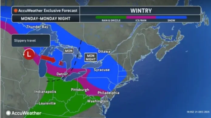
A shift in the weather pattern is setting the stage for a colder start to the week across New Jersey, with a brief window for light snow in parts of the state before milder air works its way back in. High pressure moving through the Mid-Atlantic is pushing colder air southward tonight and into Monday, reinforcing a wintry backdrop ahead of the next system.
As that high pressure slides offshore into the Atlantic, winds will turn southerly late Monday night into Tuesday, allowing warmer air to begin lifting northward. Before that transition fully takes hold, a fast-moving disturbance will ride along a developing temperature boundary, bringing a round of precipitation to the region. This system is expected to arrive late Monday night and taper off by around midday Tuesday, with the most active period occurring between midnight and mid-morning.
While moisture with this system is limited, the timing coincides with the coldest air in place, which opens the door for snow in northern portions of the state. Forecast guidance continues to point to accumulating snow mainly for areas along and north of Interstate 78, with the highest potential farther north toward Interstate 80 and the New York state line.
In North Jersey, especially in northern Sussex County and the higher elevations of Passaic County, snowfall totals of roughly two to four inches remain possible if precipitation rates briefly intensify before warmer air intrudes. Communities north of I-80 are best positioned to see measurable accumulation, while areas closer to I-78 may see snow at the onset before a quick changeover limits totals.
Central New Jersey sits closer to the transition zone. Some locations could begin with a short-lived burst of snow late Monday night, but warming at the surface is expected to prevent anything more than a light coating in most spots. South Jersey is unlikely to see meaningful snow from this system, with temperatures favoring rain for the duration of the event.
By Tuesday afternoon, the advancing warm front should end any wintry precipitation statewide, with temperatures gradually rising through the day. The overall setup reflects a familiar winter pattern, with fast-moving disturbances tracking along a sharp temperature gradient and producing narrow bands of snow where cold air briefly holds its ground.
Residents are encouraged to stay aware of changing conditions, especially during the early Tuesday morning commute in northern counties. Ongoing updates and detailed forecasts can be found through Explore New Jersey’s ongoing weather coverage in the site’s Weather Report section, which continues to monitor evolving conditions across the Garden State.


