
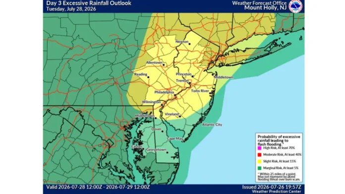

New Jersey’s weather is about to get very interesting. A fairly broad area of low pressure has taken up residence over the state, generating a flood watch from Sussex County to Cape May that covers nearly the entire state in a single weather advisory. And this system is particularly noteworthy because New Jersey is basically seeing two different storms at once, featuring different threats and different timing.
Statewide 5-Day Outlook
The entire state will remain locked under this unstable, wet pattern until a cold front finally pushes it out to sea at the end of the week.
| Region | Tuesday, Jul 28 | Wednesday, Jul 29 | Thursday, Jul 30 | Friday, Jul 31 |
|---|---|---|---|---|
| North Jersey | 🌧️ Heavy Rain / Storms (77°F) | 🌦️ AM Showers (78°F) | 🌧️ Lingering Rain (78°F) | ☀️ Sunny & Clear (84°F) |
| Central Jersey | ⛈️ Severe Thunderstorms (77°F) | 🌦️ Scattered Storms (81°F) | ☁️ Mostly Cloudy (78°F) | ☀️ Mostly Sunny (85°F) |
| South Jersey | 🌊 Continuous Downpours (77°F) | ⛈️ PM Thunderstorms (83°F) | 🌦️ Isolated Showers (79°F) | ☀️ Clear Skies (86°F) |
The big difference between the northern and central parts of the state, bound by the cities of Newark, Jersey City, and New Brunswick to the south and the New York state line to the north, is that right now, the wind is the story, not the rain. The National Weather Service has issued a warning for damaging gusts tonight as storms move through the area, with isolated reports of tree damage and power outages possible through the region. As winds die down on Tuesday, rain becomes the new story, as the band of showers pushing through the area on Tuesday afternoon threatens to cause flash floods on the already saturated ground. The threat of sudden and dangerous flooding is greatest on the main commuter roads through the region, including I-95, Route 1, and Route 22, with 3″ of rain possible in some places by Tuesday afternoon. For drivers on these routes, the combination of heavy rain and wet ground could easily turn minor puddles into major road hazards within a few hours.
Meanwhile, to the south in South Jersey, the band of showers pushing through the region is arriving later in the day and peaking after dark, covering an area bound by the cities of Cherry Hill, Atlantic City, and Vineland with a generally more moderate storm. The biggest difference between South and North Jersey is that while the wind isn’t a huge threat in South Jersey, the rain has a much higher possibility to cause flooding, particularly on Tuesday afternoon. On Tuesday morning, a formal flood watch will be issued for South Jersey as persistent rain falls over the region, soaking the ground throughout the day. Rainfall rates of over 2″ per hour are possible by Tuesday afternoon, enough to overwhelm some urban storm drains and cause isolated streams to rise over their banks before the storm finally moves out to sea.
For perspective, this storm is basically the same system affecting all of New Jersey for the next five days, with the entire state turning gradually more unsettled through the week before finally clearing up on the weekend as a cold front pushes the entire system out to sea. The peak conditions are set to occur on Tuesday, with North Jersey seeing heavy rain and thunderstorms around 77 degrees, Central Jersey seeing large areas of severe thunderstorms pushing through similar temperatures later in the day, and South Jersey seeing sheets of rain falling at nearly tropical storm rates around the same temperature.
On Wednesday, the improvement will continue, with conditions generally milder than Tuesday across the state, although still featuring plenty of moisture. North Jersey will see morning showers pushing through the region around 78 degrees, while Central Jersey should see scattered thunderstorms developing with similar temperatures and South Jersey seeing another round of afternoon thunderstorms pushing through the state around 83 degrees.
On Thursday, the trend to drier conditions will continue, with North Jersey seeing scattered rain holding around 78 degrees, Central Jersey turning more cloudy with isolated showers pushing through the state, and South Jersey cutting back to only a few showers holding around 79 degrees. This pattern will largely hold up on Friday, with the state finally seeing a return to generally dry and sunny conditions after several days of rain. North Jersey should be the coolest at 84 degrees under clear skies, while Central Jersey turns mostly sunny with slightly warmer temperatures of 85 degrees, and South Jersey sees the best conditions of the week, with 86 degrees of largely cloudless summer air.
For residents of New Jersey, conditions look very different depending on which part of the state they’re in, but there are some general guidelines for dealing with the upcoming weather. Drivers in North and Central Jersey should be especially wary of flash flooding concerns on Tuesday afternoon, particularly on the main thoroughfares through the region, while residents of South Jersey should be bracing for heavier than average rain to fall through the region throughout the day on Tuesday, threatening to overwhelm storm drains and small waterways rather than causing immediate damage to large trees or structures like lightning would in a severe thunderstorm. Either way, the entire state should see conditions notably drier on Friday morning, and residents can expect several days of generally clear, dry weather as this weather pattern moves out to sea.
















