
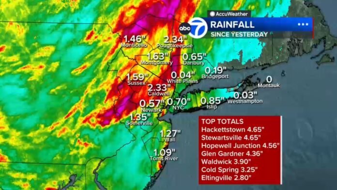

Northwestern New Jersey woke up to roads slick with rain, flash flood warnings keeping a wary eye out over the region, and a total rainfall amount that was anything but summery for a summer thunderstorm complex. Slow moving storms rolled over the area overnight, kicking in up to 10 inches of rain in parts of the state. A statewide flood watch remained in place through at least the afternoon as the deluge rolled on through the region. The morning broke up with a few breaks of partially cloudy skies across the area, allowing temps to climb to a pleasant 68, if the 95% relative humidity is anything to go by, the feels-like temp was more in the 75 range.
Hourly Forecast for Wednesday, July 29
The state will see variable clouds and a brief break from the rain today before another round of thunderstorms rolls through this evening.
| Hour | Sky Condition | Temperature | Chance of Rain |
|---|---|---|---|
| 8 AM | 69°F | 5% | |
| 10 AM | 73°F | 5% | |
| 12 PM | 77°F | 10% | |
| 2 PM | 80°F | 0% | |
| 4 PM | 82°F | 5% | |
| 6 PM | 79°F | 70% | |
| 8 PM | 74°F | 15% | |
| 10 PM | 71°F | 0% |
Looking Ahead
- Wednesday Night: Skies will clear out behind the evening storm front with periodic clouds and a low of 67°F.
- Thursday, July 30: Temperatures will drop to a cooler high of 77°F with a 65% chance of light rain showers persisting throughout the day.
Not that the poor state is done with the rain either, as meteorologists are taking special care to note that this system has arrived in two distinct pulses. The first, which has already rolled through the state over the last few hours, has spun through northern New Jersey, rotating throughout the afternoon before pulling out toward the northeast. Anyone in the northern half of the state has been impacted by the downpours, flashing rains, and frequent lightning strikes that have characterized the first pulse of this storm system. Forecasters keeping an eye on the low level rotation in the storms that weren’t overtaken by the strong mid and upper level flow kept a close eye out on possible tornadic development, that has yet to materialize as of the early afternoon check-in. The conditions the first pulse brought across the state are textbook for why storms keep getting upgraded, and why it’s always good to keep an eye out the weather even if you’ve seen a couple dozen other storms already.
What To Expect From Now Until Midnight
The second pulse of this storm complex is the one to watch for anyone in central or southern New Jersey, who have so far been spared the brunt of the damage from the storms. Forecasters are expecting this second round of thunderstorms to be the slow moving variety that has already rotated across the state from north to south, beginning around 7 or 8 in the evening and lasting until right after midnight. Thunderstorms are expected across the state for the majority of this period, peaking in the evening with a 70% chance across all counties by 6 p.m. with heavy rain expected during that peak window. Another 2-3 inches of rain across most of the state, with higher amounts possible in places that get hit with the heavier cells. Once this system finally pulls out of the state, expected to happen sometime between 2 and 3 in the morning, the rain should finally taper off, leaving the overnight hours to clear up the clouds, with the low near 67 degrees.
An hour by hour breakdown of the remainder of Wednesday shows a day divided between the cool conditions of the morning and the hot one of afternoon. Morning hours will see partly cloudy to mostly cloudy conditions with only a slight chance of rain showers, temps climbing from 69 degrees at 8 a.m. to the upper 70s by noon. Afternoon hours are relatively mild as well, with partly cloudy skies pushing the temps up into the low 80s and a slight chance of scattered showers. Then, as expected, the conditions turn back to stormy for the evening, as thunderstorms roll in around 6 p.m with that 70% chance of rain I keep mentioning, temps back down to the high 70s, and finally clearing up with another round of partly cloudy skies by 8 p.m. with conditions cooling into the mid 70s. By 10 p.m, if things go according to plan, we can expect clear skies across the state with a comfortable 71 degrees.
Not Done With Rainfall Yet
If you’re hoping for a dry weekend, prepare to be slightly disappointed. Thursday is set to see a slight decrease in the high temps across the state to a still quite warm 77 degrees, but also sees an increase in the chance for scattered light rain showers. This is expected to persist throughout much of the day rather than come and go within a short period, as the slow moving storm complex brings in more rounds of rain and thunderstorms to the state. Forecasters keeping an eye on the complex are noting that this system’s low pressure center is moving slow, and is held back by an upper level low further to the west that is also unwilling to move on. This will prolong the amount of time this system keeps bringing rain to New Jersey, and will extend into at least Friday with additional periods of light rain, drizzle and breezy conditions out of the north or northwest.
The silver lining to all of this persistent rain is that the weekend is looking to be quite nice, as the slow moving storm complex finally moves out of the area. Both Saturday and Sunday are expected to see periods of rain showers ease up, allowing temps to creep back up to normal late July levels.
Much Needed Rainfall, Just Not Quite What Some Needed
There is one major caveat to all of this persistent rainfall, and that caveat falls under the category of much needed rainfall across the state. Despite the flash flooding warnings and the poor driving conditions that have plagued parts of northern New Jersey overnight, this storm complex has brought exactly what the state needed in terms of precipitation. The distribution of rainfall has been skewed, with the northern half of the state receiving more precipitation than the southern one, but overall it’s a boon to see the rain fall across the state in the middle of the dry summer. The uneven distribution might be something for residents of northern New Jersey to gripe about as they continue to wade through the standing water left in the wake of the storm system, but for the rest of the state, that much needed boost in moisture levels is something that will help reservoirs and the ground itself as they head into August.
















