New Jersey residents can expect a shifting pattern this week as the state transitions from a soggy start to drier and slightly warmer conditions before the Thanksgiving holiday. The upper-level flow across the Eastern United States remains predominantly zonal, keeping weather systems moving quickly across the region, while subtle ridges and troughs will produce alternating periods of milder and colder air. For a deeper look at local conditions and updates, Explore New Jersey’s weather report coverage provides timely information for planning travel and outdoor activities.
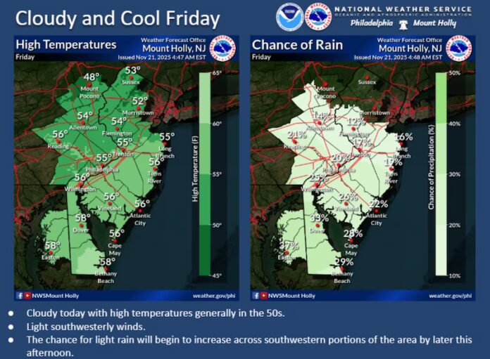
Friday, November 21, starts off cool and mostly cloudy, with highs reaching the mid-50s in most areas. Occasional breaks in the clouds may allow for some sunshine, but periods of rain are expected to move in during the evening and overnight. Winds will remain light out of the southwest, and overnight lows will dip into the 40s to low 50s as the rain continues into Saturday morning.
By Saturday, November 22, conditions begin to improve. Highs are expected to climb into the low-to-mid 50s, with lingering morning clouds and scattered showers gradually giving way to brighter skies by late morning and afternoon. Winds will shift light out of the north and northwest, and temperatures overnight will fall sharply, especially in northwestern New Jersey where elevations may see lows dipping into the 20s. Elsewhere, most areas will settle into the 30s as clear skies prevail.
Sunday, November 23, offers a reprieve with high temperatures in the upper 40s to lower 50s. Sunshine will mix with clouds, providing a more comfortable day for outdoor activities. Light westerly or southwesterly winds will accompany the mild afternoon conditions. Overnight, temperatures will remain chilly, ranging from the low 30s in northern parts of the state to around 40 degrees in southern areas.
Looking ahead to the week of November 24-28, New Jersey will experience a mild pre-Thanksgiving surge. Tuesday and Wednesday could see highs climbing into the lower 60s in some locations, offering a brief warm-up before a cold front moves through the region. This front is expected to bring rain to coincide with Black Friday and Thanksgiving travel, along with a return to cooler conditions for the holiday weekend. Early indications suggest a mild first week of December, potentially reaching into the 50s before a more persistent cold pattern takes hold in the second and third weeks of the month, setting the stage for the start of winter.
This week’s weather pattern can be thought of as a series of oscillating swings: the wet start on Friday, a brief sunny improvement over the weekend, a mild midweek boost, and then a chilling shift as Thanksgiving approaches. Rainfall timing will be crucial for travelers and outdoor plans, particularly for those making their way across the state for holiday gatherings. The interplay of warmer pre-holiday days and subsequent cooler air underscores the importance of monitoring forecasts closely as the season transitions from autumn into early winter.
Residents planning activities this week should prepare for variability: light rain and overcast skies at the start, bright and cool conditions over the weekend, and potential travel impacts from rain and colder temperatures around Thanksgiving. With highs in the 50s to lower 60s before the holiday and lows dipping near or below freezing in elevated areas, layering and attention to forecast updates will help ensure comfort and safety. This evolving pattern highlights New Jersey’s dynamic late-fall weather, a blend of wet beginnings, sunny interludes, and the cold snaps that herald the approach of winter.


