As the Garden State transitions from a cool fall week into a dynamic weekend, meteorologists are keeping a close eye on shifting patterns in the upper atmosphere that will dictate temperatures, cloud cover, and rainfall over the next several days. The upper jet stream is currently oscillating between troughs and ridges, creating a variable weather pattern for New Jersey. The departing trough has delivered a chillier air mass earlier this week, but a modest ridge moving in for the weekend will provide a temporary warm-up before more active weather returns next week.
Friday offered residents a crisp, quintessential autumn day. Highs reached the low-to-mid 60s across most of New Jersey under mostly sunny skies. A light north-to-northwest breeze kept conditions refreshing, while overnight lows fell into the 30s for inland areas, with the potential for frost in northern and western locations. Coastal regions stayed milder, with temperatures lingering in the mid-40s. Gardeners and outdoor enthusiasts were treated to a beautiful fall evening and clear skies, perfect for wrapping up the workweek.
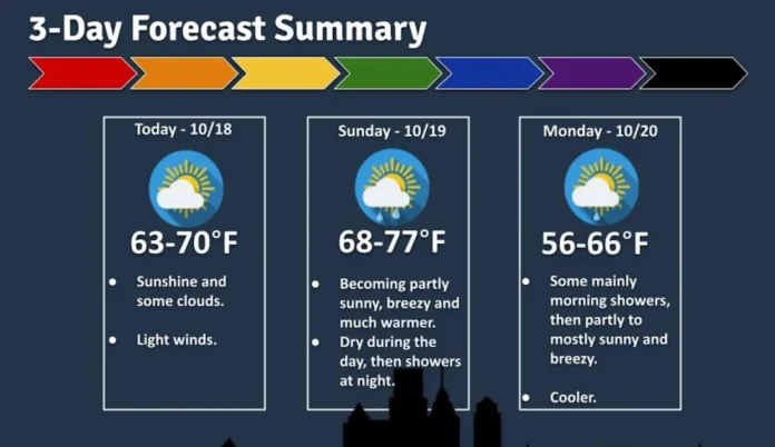
Saturday promises the sunniest conditions of the weekend, with highs climbing into the 65-70 degree range across most locations. The day will feature a pleasant mix of sun and clouds, and light winds from the west and southwest will make outdoor activities comfortable. Overnight, temperatures will dip into the 40s inland and remain slightly warmer near the coast, in the 50-55 range, creating another crisp but manageable autumn night. This will be the ideal day for farmers, hikers, and residents looking to enjoy outdoor fall activities.
Sunday brings a warmer but cloudier forecast as a warm sector pushes into the state ahead of an approaching cold front. Daytime highs are expected to reach the low-to-mid 70s, marking the warmest day of the weekend. Winds will shift out of the south and southwest, adding a mild, late-October feel. While most of Sunday will remain dry, rainfall is expected to arrive late in the evening, transitioning into overnight showers that could persist into early Monday morning. Meteorologists are monitoring whether the incoming front will remain a standard system delivering light rain or whether secondary surface development along the front could enhance precipitation totals. In areas that experienced lower rainfall from the recent nor’easter—particularly northwest, west-central, and northern New Jersey—this could provide a welcome boost. Coastal and southeastern counties are likely to see less impact from the late Sunday rainfall.
Looking ahead to next week, Monday will start with lingering showers across parts of the state. Conditions are expected to improve during the day, with high temperatures settling in the mid-to-upper 60s under zonal, westerly flow. Tuesday will maintain mild conditions, although temperatures will likely not sustain the highs of Sunday. By midweek, a deeper trough will push through, bringing another cold front and a return to the cooler, crisp autumn pattern typical for this time of year, with highs generally in the 50s to low 60s.
Residents are encouraged to enjoy the weekend, particularly Saturday, which will be the sunniest and most temperate day before the wet and cooler air moves in. Farmers and gardeners will find Saturday and early Sunday ideal for outdoor work, while Sunday evening and Monday morning may provide much-needed moisture for areas that remain dry.
For ongoing updates on New Jersey weather, forecasts, and alerts, visit Explore New Jersey Weather Report to plan your week ahead and stay informed about changing conditions across the state.


