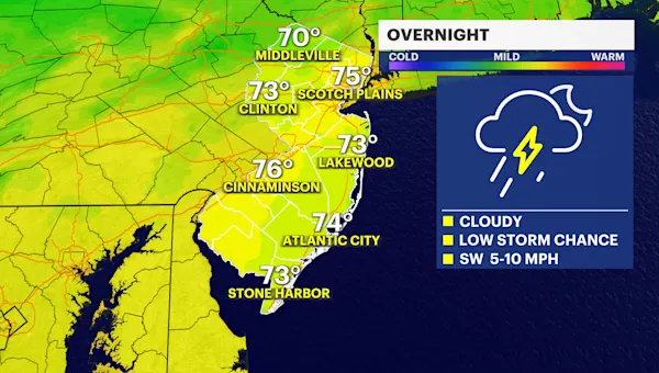
New Jersey’s summer weather continues its pattern of warmth, humidity, and the potential for impactful thunderstorms. Following a lively Tuesday night that saw intense storms rumble through West and South Central New Jersey before losing some steam closer to the coast, Wednesday promises a similar, if not intensified, encore. While Northern New Jersey experienced a calmer evening yesterday, the focus for tonight’s most significant weather action will once again be on the central and southern portions of the state. For continuous updates and detailed forecasts that help you navigate the ever-changing New Jersey skies, make sure to visit our Weather Report.
The Atmospheric Setup: Why Tonight Matters
Understanding today’s weather requires a quick look at the atmospheric mechanics at play. A “stationary boundary” – essentially a subtle yet potent line where different air masses meet but don’t actively push each other – is draped across South and Central New Jersey, roughly paralleling the vital I-95/New Jersey Turnpike corridor. This boundary acts as a crucial “lifting trigger,” forcing warm, humid air upwards.
Adding to this setup, a system carrying significant storm energy is currently making its way across Southwestern Pennsylvania, Western Maryland, and West Virginia. As this energy pushes eastward towards the Garden State later today and tonight, it will interact with our stationary boundary. Just like yesterday, the conditions are ripe for another stormy evening: ample “diurnal destabilization” (meaning the sun’s heating during the day creates atmospheric instability), sufficient wind shear, and that essential lifting mechanism provided by the boundary.
Where and When to Expect the Action
Given these atmospheric dynamics, the heaviest and most intense thunderstorms tonight are primarily targeting the western side of Central and Southern New Jersey. Think of I-195 as a dividing line: areas north of this east-to-west highway might experience some showers and rumbles, but the southern half of the state, including all of South Jersey and much of Central Jersey south of I-195, is “on the hook” for the more severe potential. Southwestern New Jersey, in particular, could be ground zero for the strongest activity.
The timing for the main event appears fairly straightforward: a linear storm front is expected to arrive in Western New Jersey around 9:00 PM. This impactful line of storms will then sweep across the state from 9:00 PM to midnight, finally departing Eastern New Jersey with any lingering showers or rumbles by approximately 2:00-3:00 AM. It’s worth noting that a few isolated cells could develop ahead of this main front anytime from late afternoon into the early evening.
What to Expect and How to Stay Safe
In plain terms, brace for another stormy night across much of New Jersey. While some scattered showers and thunderstorms are possible this afternoon and early evening, the primary round of storms will move through later tonight. As is often the case with New Jersey’s coastal geography, any intense weather pushing from the west might weaken as it approaches the eastern parts of the state. This is largely due to the moderating influence of the marine air and the loss of daylight, which reduces the atmospheric energy needed to sustain severe storms.
Even with potential weakening, residents should prepare for isolated instances of damaging winds, downpours that could lead to localized flash flooding, and frequent lightning. These are the classic hallmarks of strong summer thunderstorms in our region. Looking beyond tonight, the rest of the week appears to continue this pattern of relentless humidity, though Thursday currently looks to be the least rainy or stormy day on the forecast.
Stay vigilant, keep an eye on local alerts, and ensure you have a plan in place for severe weather. Have a safe and dry night, New Jersey!


