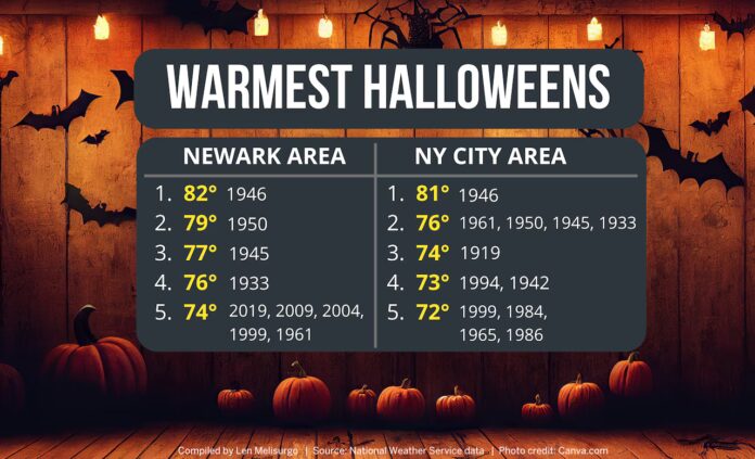
As Halloween approaches, weather forecasters are keeping a close eye on potential storm activity that could impact trick-or-treating and seasonal celebrations across New Jersey. Meteorologists have been monitoring long-range model data for the past week, and while forecasts remain fluid, several signals suggest at least some precipitation may affect the region around October 31. Residents and event planners are advised to stay alert and prepare for possible shifts in timing and intensity. More local weather updates can be explored at https://explorenewjersey.org/category/weather-report/
Currently, the Eastern U.S. is under the influence of a persistent trough, keeping temperatures cooler than seasonal averages and skies mostly dry through the upcoming weekend. A brief break in this pattern is expected early next week, allowing slightly warmer and calmer conditions for a short period. However, models indicate that another trough may develop late next week, coinciding with the Halloween period and potentially triggering unsettled weather.
Meteorologists are also monitoring Tropical Melissa, which is forming in the Caribbean. While historically late-season tropical systems have occasionally threatened the U.S. East Coast—such as Hurricane Sandy in 2012—current projections suggest Melissa is likely to remain offshore, steered away by atmospheric currents associated with next week’s trough. Forecasters caution that interactions between the tropical system and the approaching trough could still influence regional weather, although the probability of a direct coastal impact is low at this time.
Forecast models diverge in terms of timing and severity for New Jersey. The GFS model indicates a surface low could develop along the Southeast coast next week, moving northward and bringing rain and gusty winds to New Jersey during Halloween evening. Should this scenario verify, trick-or-treating could face interruptions, with moderate to heavy rainfall in some areas. Meanwhile, the European model suggests a weaker, less organized low that would allow precipitation to taper off by Thursday, leaving a dry but potentially chilly Halloween with northwest winds. The Canadian model presents another scenario, with rain holding off until late on Halloween night or early November 1, which would still permit trick-or-treating but could bring a more significant coastal storm in its aftermath.
Meteorologists emphasize that a week out, forecasts are still evolving, and model agreement typically solidifies only a few days before the event. Residents are encouraged to monitor local weather updates closely, maintain flexibility in Halloween plans, and consider contingency arrangements in case of rain or wind. Even a brief period of dry weather could make a significant difference for families and community events.
Whether it turns into a damp Halloween or merely a cooler, breezy evening, planning ahead will ensure children and communities can enjoy the holiday safely. Keeping an eye on Tropical Melissa and the development of next week’s trough will be critical for determining the likely weather scenario as the week progresses.
For those wanting daily updates, tips for planning around potential storms, and guidance on safe outdoor activities, more detailed forecasts and insights are available at https://explorenewjersey.org/category/weather-report/
The coming week promises a dynamic weather setup for New Jersey, and forecasters will be tracking conditions closely to provide accurate guidance for Halloween festivities. Families and event organizers should stay prepared for last-minute changes while hoping for at least a portion of the holiday to remain dry and enjoyable.


