New Jersey is set to experience a noticeable drop in temperatures this week as an upper-level trough swings across the Eastern United States, drawing a lobe of Arctic air down into the region. While not extreme by winter standards, the cold will feel unusually intense for early November, with wind chills likely plunging into the teens and low 20s during the coldest overnight periods. Daytime highs on Tuesday are expected to struggle to reach the 40-degree mark across much of the state, with coastal areas seeing slightly warmer readings in the low-to-mid 40s.
The upper atmosphere is dominated by a 250mb jet streak and a pronounced trough, creating a strong Positive Vorticity Advection (PVA) zone. This dynamic injects Arctic air into the trough while supporting the formation of surface lows offshore. The trough’s influence has already pushed a cold front through the state, leaving Monday’s temperatures across New Jersey in the 48–53-degree range, barely above the morning lows. After sunset Monday, temperatures are expected to drop sharply, with most inland areas falling below freezing by early Tuesday morning. Tuesday night into early Wednesday will be another period of cold, though readings will gradually rebound toward seasonally average levels by midweek.
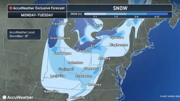
One of the more notable impacts of this early-season Arctic air is the potential for lake-effect snow. With cold air moving over the relatively warm Great Lakes and the presence of a near-coastal surface low, New Jersey could see scattered flurries or very light snowfall from Monday night through early Wednesday. Accumulations are expected to be minimal, with the best chance for light dusting in the elevated terrain of Northwest New Jersey. The flakes may reach as far south as the Turnpike corridor, though no significant snow is anticipated. Tuesday appears to be the peak day for any such light snow events.
Following this brief cold snap, New Jersey is expected to dry out through at least Saturday, November 15, with temperatures gradually returning to near-normal readings for mid-November. A few disturbances may bring precipitation Sunday into the following week, but current indications suggest conditions will be too warm for snow, signaling that the true snow-tracking season is still a few weeks away.
In practical terms, residents should prepare for a chilly start to the week, with N/NW winds enhancing the Arctic feel. Jackets, hats, and gloves will be necessary for anyone spending time outdoors, and heaters will likely be in steady use overnight and during the morning commute. For those curious about seeing the first flurries of the season, elevated areas in Northwest New Jersey will provide the best chance, while southern and coastal regions may only experience cold, windy conditions with the occasional floating snowflake.
This week’s pattern highlights how early November can occasionally deliver taste-of-winter conditions, with Arctic intrusions providing a glimpse of what’s to come in the colder months. While temperatures will remain far from mid-winter extremes, the state’s residents will feel the contrast sharply compared to seasonal averages, making for a crisp start to the week and a reminder that winter is just around the corner.
For ongoing updates and detailed forecasts for New Jersey weather events, including snow tracking, Arctic intrusions, and temperature anomalies, visit Explore New Jersey’s Weather Report section.


