A weak disturbance is moving through the Mid-Atlantic this weekend, bringing scattered rain to parts of Central and South Jersey before quickly clearing out. Most precipitation overnight is expected to remain southeast of I-95 and the New Jersey Turnpike corridor, with showers tapering off by early Sunday morning. Communities northwest of the I-95 corridor are likely to miss much of the rainfall, and once this system exits, the region may settle into a drier stretch of weather.
Attention, however, has shifted to the tropics, where Hurricane Humberto has rapidly strengthened into a Category 5 storm. As of late Saturday, Humberto was positioned about 600 miles east of the Bahamas and 500 miles southeast of Bermuda. Forecast models remain consistent, keeping the hurricane just west of Bermuda before it curves back out to sea. While the United States coastline is expected to avoid direct impacts, Bermuda is preparing for heavy rain, damaging winds, and storm surge between Monday and Wednesday, with the brunt of the storm likely on Tuesday. Any eastward shift in Humberto’s path could result in a more direct strike on the island.
For New Jersey, Humberto will not bring rain or wind, but its influence will be felt along the shoreline. Beginning Monday evening and lasting through midweek, coastal communities should prepare for rough surf, elevated wave heights, dangerous rip currents, and possible beach erosion. Swimmers and surfers alike should use caution as hazardous marine conditions develop. Residents can follow ongoing weather updates across New Jersey for local impacts.
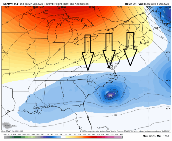
Meanwhile, another tropical system—currently identified as Tropical Depression Nine and expected to strengthen into Tropical Storm Imelda—remains in play. While not projected to threaten New Jersey directly, its eventual path will be determined by a strong ridge of high pressure building southward from Canada. Meteorologists describe this ridge as creating a “block” along the East Coast, which may force Imelda to remain offshore.
Two main scenarios are being considered. If the ridge pushes Imelda out to sea, the system will follow Humberto into the Atlantic, keeping New Jersey dry. However, if Imelda becomes trapped beneath the high-pressure system, it could stall south of the Outer Banks of North Carolina. Such a stall would likely weaken the storm, but the remnants could eventually slide north and bring rain to the Garden State later in the week. The situation remains uncertain, and forecasts will be closely monitored in the coming days.
Regardless of Imelda’s outcome, a strong cold front is poised to sweep through New Jersey by midweek, ushering in the sharpest temperature drop of the season. After several weeks of warm, late-summer conditions, highs are expected to only reach the 60s on Wednesday and Thursday, with overnight lows dipping into the 40s in some areas. This crisp air mass will mark the arrival of true autumn weather across the state. Residents can expect a noticeable shift beginning Wednesday morning, with dry and refreshing conditions taking hold.
The timing of this front coincides with the departure of Humberto and the uncertain path of Imelda. Should both tropical systems remain out to sea, New Jersey could enjoy a string of dry, cool days heading into the weekend. If Imelda’s remnants drift up the coast, however, unsettled weather could return by next weekend, bringing showers to the region.
As September winds down, the pattern points toward a mix of late-summer warmth and early fall chill. Coastal impacts from Humberto and the potential influence of Imelda serve as reminders of the power of the tropics even when New Jersey is spared a direct hit. For now, Garden State residents can look forward to cooler days, crisp evenings, and a seasonally appropriate start to October.


