For the week of Friday, September 26, to Friday, October 3, 2025, New Jersey will see a mix of conditions, including a rainy weekend followed by a trend toward drier, cooler weather later in the week. Weekly forecast…
Friday, September 26 (Today)
- Conditions: Partly cloudy with high temperatures around 80°F.
- Rain: Low chance of rain during the day and overnight.
Saturday, September 27
- Conditions: The start of the weekend brings a chance of light rain and mainly cloudy skies.
- Temperature: Expect a high of 78°F and a low of 63°F.
- Rain: A higher chance of rain is expected overnight.
Sunday, September 28
- Conditions: Continuing mostly cloudy with a chance of showers.
- Temperature: Highs will reach 76°F with lows around 60°F.
Monday, September 29
- Conditions: Mostly cloudy with a slight chance of rain.
- Temperature: High temperatures rebound to 79°F, with lows around 62°F.
Tuesday, September 30
- Conditions: The skies will be mostly cloudy during the day.
- Temperature: High of 74°F, with lows dropping to 60°F.
Wednesday, October 1
- Conditions: Partly cloudy skies with a definite cool-down.
- Temperature: A colder day is expected, with a high of 68°F and a low of 51°F.
Thursday, October 2
- Conditions: Clear and cool conditions are expected.
- Temperature: Highs will only reach 62°F, with lows dropping to 49°F.
Friday, October 3
- Conditions: Drier, partly cloudy weather continues.
- Temperature: Highs around 67°F and lows around 53°F.
After a relatively calm start to the 2025 hurricane season for New Jersey, meteorologists are now tracking renewed activity in the Atlantic Basin. Three tropical systems are currently drawing attention, each with different implications for the East Coast and, in particular, New Jersey.
The first system, Tropical Storm Gabrielle, poses minimal risk to New Jersey and the broader Eastern Seaboard. Gabrielle, which passed just east of Bermuda last week, generated some elevated surf along the Jersey Shore but otherwise remained out to sea. The storm is now moving across the western Atlantic toward Europe, possibly passing near the Azores, and is no longer a concern for U.S. interests.
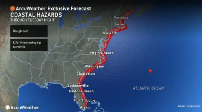
Attention now shifts to Tropical Storm Humberto, located a few hundred miles northeast of the Lesser Antilles. Forecast models suggest Humberto will largely remain over open waters, curving near Bermuda between September 28 and October 1. While this track could produce impacts in Bermuda, the storm is expected to have little more than an increase in surf and rip currents along New Jersey’s coast, with no significant rain or wind anticipated.
The system drawing the closest scrutiny for potential U.S. impacts is currently designated Invest 94L by the National Hurricane Center. Forecasters anticipate this system could develop into Tropical Depression 9 and eventually be named Imelda if it strengthens into a tropical storm or hurricane. Current projections place Imelda tracking along the northern Greater Antilles and the Bahamas before approaching the Southeastern U.S. coast, somewhere between Jacksonville, Florida, and the Outer Banks of North Carolina around September 29–30.
Weather patterns and a strong high-pressure system over southeastern Canada and the northeastern U.S. suggest that Imelda could stall over the southeastern states rather than moving directly toward New Jersey. Some of the storm’s outer bands may reach southern New Jersey, but the core of the system is likely to remain well to the south and southwest. Should Imelda weaken inland, its remnants could eventually swing northeast, potentially bringing rain to parts of New Jersey later next week.
Forecasters briefly considered a rare “Fujiwhara effect,” where two nearby tropical systems orbit a central high-pressure area, which could have created a chaotic scenario. Current guidance, however, indicates that Humberto will stay out to sea while Imelda heads toward the Southeast U.S., reducing the likelihood of such an interaction.
In the immediate term, New Jersey residents should prepare for unsettled weather over the next 24 hours. Thursday is expected to remain muggy, with rain and isolated thunderstorms continuing into early Friday morning. A passing cold front will reduce humidity slightly, lowering dew points from the 70s into the 60s, but truly comfortable conditions—dew points in the 40s and 50s—may not arrive until Tuesday or Wednesday of next week. This will make for a stormy Thursday night, followed by improved weather Friday, with scattered showers possible Saturday night into Sunday morning.
Overall, there are no direct hit threats to New Jersey from either Humberto or Imelda at this time. The most immediate impacts will be elevated coastal surf from Humberto and potential rainfall from Imelda’s remnants later next week. Weather patterns remain dynamic, and forecasts may evolve rapidly, so residents should monitor updates from local authorities and reliable sources. For the latest on New Jersey’s weather and tropical developments, see Explore New Jersey’s weather coverage.


