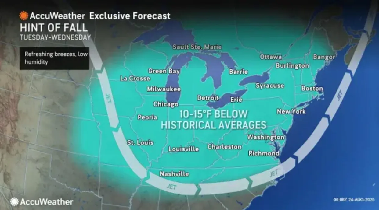
As summer edges toward its final act, New Jersey is about to enjoy one of those rare, magical stretches of weather that make late August and early September so special. A cold front is sliding across the state from west to east, dropping dew points that were near 70 this morning into the comfortable 50s by mid-afternoon. For Garden State residents, that means the suffocating humidity we’ve endured for weeks is finally giving way to crisp, dry air and pleasant skies.
While most areas will stay dry today, the atmosphere could still squeeze out an isolated, hyper-localized pop-up shower or storm along the frontal boundary. But for the vast majority of New Jersey, this front signals the start of a string of refreshingly dry, comfortable days—perfect timing with Labor Day right around the corner.
For those who track weather patterns, this setup is tied to a series of upper-level troughs swinging through the Mid-Atlantic and Northeast. With New Jersey sitting on the backside of these systems, we’ll lock into a northwest flow that brings sunshine, lower humidity, cooler nights, and a break from summer’s relentless heat.
You can follow updates like this in our New Jersey Weather Report section, where we track daily conditions, storm threats, and seasonal transitions.
The Forecast: A Week of Comfortable Days and Chilly Nights
Here’s how the next several days are shaping up across New Jersey:
Monday, August 25
- Highs: Low-to-mid 80s
- Conditions: Sun and clouds with just a slim chance of an isolated shower or thunderstorm. Most areas will stay dry.
- Winds: Shifting from southwest to west/northwest with the front.
- Overnight Lows: 50s to low 60s, with coastal towns staying just above 60.
Tuesday, August 26
- Highs: 75–80° statewide.
- Conditions: More sun than clouds, lower humidity, and a refreshing feel.
- Winds: Light from the W/NW.
- Overnight Lows: 50s across much of the state, dipping into the cooler range inland.
Wednesday, August 27
- Highs: Mid-to-upper 70s.
- Conditions: Another gem—sun mixed with some clouds, dry and pleasant.
- Winds: Light, occasionally breezy, from the W/NW.
- Overnight Lows: Crisp! Mid-40s in northwestern NJ to around 50s along the southern coast. Could be the best-feeling night of late summer so far.
Thursday, August 28
- Highs: Upper 70s to low 80s.
- Conditions: Mostly sunny, still comfortable.
- Winds: Light from the southwest.
- Overnight Lows: Low 50s to low 60s from north to south.
Friday, August 29
- Highs: 75–80° across most of NJ.
- Conditions: More clouds with the chance of showers tied to an upper-level disturbance.
- Winds: Light to breezy from the S/SW.
- Overnight Lows: 50s inland, low 60s at the shore.
Saturday, August 30 – Labor Day Monday, September 1
- Highs: Comfortable 70s to low 80s each day.
- Conditions: Sunshine dominates with friendly clouds here and there. Dry skies expected.
- Overnight Lows: Cool but not cold, ranging from the 50s inland to low 60s near the shore.
Seasonal Shifts: From Strange Summer to Fall’s Approach
This late-August stretch feels like a reward after what has been a rollercoaster summer. We began the season with drought concerns, shifted into a stormy and rainy pattern, endured weeks of high humidity, and now find ourselves in this almost autumn-like setup. It’s as if 2025 wanted to show us every version of summer in a single season.
Looking ahead, the pattern suggests no imminent return of unbearable heat or high humidity. Could we still see a September or even October heatwave with 90° days? Absolutely—it’s happened before. But for now, the immediate forecast looks locked into a mild, comfortable mode.
We’ve already lost 103 minutes of daylight since the solstice, and every evening sunset is a reminder that autumn is creeping closer. For students and teachers, the timing feels like “summer over.” For beachgoers, boaters, and pool owners, this week may be the unofficial curtain call. But for lovers of fall foliage and snowy winters, the shift brings excitement. A colorful autumn could be just weeks away, followed by the kind of winter New Jersey snow fans dream about.
Watching the Tropics
It’s worth noting that we’re in the peak of Atlantic hurricane season. At the moment, no immediate threats are targeting New Jersey, but it’s always smart to stay alert this time of year. Any tropical activity could shift the long-range outlook. For now, though, the coast looks clear—literally and figuratively.
If you’ve been waiting for a stretch of near-perfect late-summer weather, New Jersey is delivering. Expect bright skies, cool nights, comfortable afternoons, and just one small hiccup in the form of Friday’s possible showers. Beyond that, Labor Day weekend looks outstanding, setting the stage for one of the best outdoor stretches of 2025.
As we trade pool days for crisp mornings and football tailgates, enjoy this rare balance of summer warmth and autumn freshness. This is New Jersey at its best.


