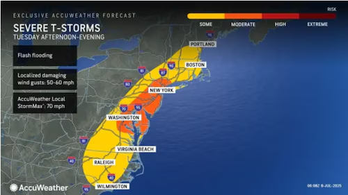
New Jersey is currently experiencing a classic mid-summer tropical air mass, driven by the lingering influence of what was once Tropical Storm Chantal. While Chantal has now been classified as a Post-Tropical Storm, its remnants are continuing to impact our weather, bringing with them relentless humidity and the potential for spontaneous, impactful thunderstorms throughout the week.
The center of Chantal’s circulation is currently near the Virginia Beach/Southern Delmarva area, and while its cyclonic winds are very weak, the overall wind direction is still strong enough to create wind shear against the general southerly flow dominating our region. This interaction is the key to the muggy conditions we’re experiencing. Dew points are soaring into the 70s, even approaching 80 in parts of Southern New Jersey. When combined with actual air temperatures in the 80s (and pushing 90 along the I-95/NJ Turnpike corridor), we’re seeing heat indices – what it actually feels like – ranging from 95 to 102 degrees.
This type of tropical air mass means that the atmosphere is incredibly unstable. As a result, seemingly peaceful cumulus clouds can rapidly develop into thunderstorms, seemingly out of nowhere. We can expect isolated to scattered thunderstorms to form throughout the day, particularly this evening. These storms are often “pulsers” – they’ll dump heavy rain, produce lightning, and possibly some straight-line winds, then quickly dissipate due to a lack of sustained updraft. However, the downdraft from these collapsing cells can then trigger new cells nearby, creating a continuous cycle of pop-up storms.
It’s crucial not to underestimate the “dirty energy” left behind by a fizzling tropical cyclone. While the primary concerns from these storms will be heavy downpours and frequent lightning, the lingering shear from Chantal’s remnants introduces a small, non-zero possibility of isolated tornado formation. These localized events, though rare, can develop quickly and warrant attention. The most noticeable features will likely remain the torrential rainfall and vivid lightning displays.
Looking ahead, this humid and unsettled pattern is expected to persist for the remainder of the week. We’re not anticipating any large-scale, organized storm systems, but rather localized, or “mesoscale,” activity. This means plenty of sunshine will mix with hazy, hot, and humid conditions, punctuated by those random isolated storm chances.
Here’s a closer look at what to expect day by day:
Tuesday (July 8): Most of New Jersey will see high temperatures reaching the lower 90s, with northwestern elevations and coastal areas hovering in the mid to upper 80s. It will be a typical mid-summer tropical mix of sun, clouds, showers, and thunderstorms, maintaining that very humid feel. Winds will be light out of the west or southwest. Overnight lows will generally range from 68-75 degrees across the state, with thunderstorm chances continuing into Wednesday morning.
Wednesday (July 9): Highs should settle into the mid to upper 80s for most of the state, but with the elevated humidity, it will continue to feel well into the 90s. While not as unsettled as Tuesday, there’s still a chance for isolated showers and thunderstorms amidst an otherwise sunny day with some cloud cover. Winds will be light out of the south or southwest. Overnight lows will remain above 70 statewide, with the exception of the highest northwestern elevations, which might dip into the mid to upper 60s. Isolated thunderstorms are possible overnight.
Thursday (July 10): Temperatures will cool slightly, with highs closer to 80 degrees, but the humidity will still make it feel more like 85-90. Expect another mixed bag of tropical mid-summer weather conditions: sun, clouds, showers, and thunderstorms, all with that persistent humid feel. Light winds will come from the south or southeast. Overnight lows will range from 65-73 degrees, with more isolated thunderstorm chances.
Friday (July 11): High temperatures might struggle to escape the 70s across much of New Jersey. This day looks to be stormier, more akin to Monday and Tuesday, rather than just isolated storms. Elevated humidity will remain in place. Winds will be light to breezy out of the east or northeast. Overnight lows will again range from 65-73 degrees, but with slightly reduced thunderstorm chances compared to earlier in the week.
Looking further ahead into the upcoming weekend (July 12-13), current indications point to continued unsettled conditions with the possibility of rain and storms. Temperatures are expected to max out in the low to mid-80s, falling to 65-72 overnight. The elevated humidity is forecast to stick around until a hopeful cold front finally arrives early next week.
For the latest updates and detailed weather information to help you navigate these muggy and stormy summer days, be sure to check our dedicated weather report section at https://explorenewjersey.org/category/weather-report/. Stay hydrated, stay safe, and be prepared for those sudden downpours!


