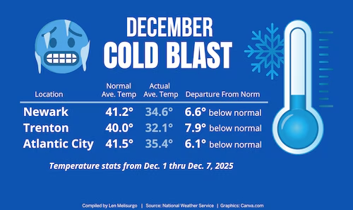
New Jersey residents are feeling the chill this December as stratospheric warming and polar vortex elongation are driving below-average temperatures across the state. A southward-dipping polar jet stream has anchored itself from Montana down through the Midwest and extending eastward into the Mid-Atlantic, creating a corridor of cold air for New Jersey while milder conditions persist to the south and west. This jet stream acts like a highway for passing low-pressure systems, often referred to as Alberta Clippers when they originate in western Canada. These systems, while typically dry and producing only light, fine snow, can occasionally merge with subtropical energy to produce more substantial precipitation.
So far, New Jersey has seen a series of these clippers clip the state. Earlier this week, a snow system passed through the Mid-Atlantic, leaving parts of Virginia and the Carolinas blanketed in snow while New Jersey largely stayed dry, with only the southern portion of the state feeling a light dusting. Behind this wave, colder air has moved in, creating frigid overnight temperatures. Residents should expect lows ranging from the single digits in northern elevations to the teens along the southern coast through Tuesday morning, with daytime highs lingering between 27 and 35 degrees statewide.
Tuesday brings another cold day, dominated by dry conditions and persistent north winds, keeping much of the state below the freezing mark. Temperatures remain steady into Tuesday night and Wednesday morning as a new weather system approaches, bringing a mix of milder air in the coastal plain and piedmont regions. By Wednesday, areas south of I-78 and east of I-287 are expected to see rain, while northwest regions could receive several inches of snow at higher elevations, with a wintry mix in the mid-elevations. Following this system, Thursday through Saturday will bring a return to colder, dry conditions, with highs on the coastal plain warming slightly to near 40 degrees on Saturday.
The weekend may bring more significant snowfall potential as two systems, initially projected for mid-December, begin to converge. Meteorologists are monitoring a wave currently targeted for late Saturday night through Sunday evening, which has shown strong consistency across major forecast models including the GFS, European, and Canadian operational runs. If conditions continue to align, this system could deliver the first widespread snowfall of the season for much of New Jersey, potentially accompanied by plummeting temperatures early next week, with highs near 20 degrees and lows in the single digits.
The repetitive flow of clipper systems highlights a pattern of thermal gradients: as each wave passes, it lifts milder air ahead and drags cold air behind, setting up a boundary for subsequent systems to follow. While earlier waves missed New Jersey to the north and south, the approaching weekend system has the potential to strike closer to ideal conditions, combining northern cold air with southern moisture for a more impactful snowfall. Residents are encouraged to monitor developments closely as details solidify in the coming days.
This week serves as a reminder of the dynamic winter weather patterns affecting New Jersey, where even modest Alberta Clippers can significantly influence temperatures and local precipitation. With the potential for a significant snow event this weekend and below-average temperatures continuing into next week, New Jerseyans should prepare for a true midwinter feel ahead of the holiday season. For continuous updates, snowfall tracking, and detailed forecasts, visit weather report.


