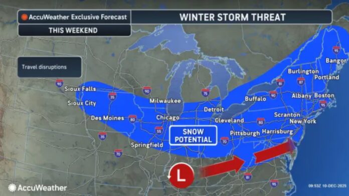
New Jersey residents should prepare for a mix of winter precipitation on Wednesday, December 11, 2025, as a trailing low-pressure system moves across the region. The first wave, tracking through southeastern Canada Tuesday night, will leave New Jersey unaffected, but it establishes a thermal boundary that will guide a second, stronger system from the Great Lakes across northern New York and into New England. This secondary system is expected to deliver snow, ice, and rain to parts of the state between roughly 10 a.m. and 6 p.m. Wednesday.
The precipitation is forecast to begin in a milder air mass, which could create initial snow, rain, or ice mixes in northwestern New Jersey. By midday, the snow/rain line is projected to settle near the I-78/I-287 corridor. Northern counties, particularly Sussex and Warren, will likely experience the most significant snowfall, with a “snow thump” expected between noon and mid-afternoon before tapering off by late afternoon. Meanwhile, central and southern regions of the state are expected to see primarily rain, though brief periods of sleet or wintry mix are possible in higher elevations closer to the northern snow line.
Weather models also suggest a wildcard scenario: if precipitation begins earlier than anticipated, surface temperatures in parts of northwestern New Jersey could drop below freezing sooner, resulting in higher snow accumulations and a more extensive wintry mix extending farther south—though likely not reaching the I-95 corridor. Without a high-pressure system to reinforce colder air from the north, warming along the coastal plain is expected to prevail, limiting snow to the northern third of the state.
Looking ahead to the weekend, meteorologists are monitoring additional snow potential, though the timing and intensity remain uncertain. A light wave of snow showers may affect southern New Jersey on Friday, while a more significant statewide event is possible Saturday night into Sunday. Tracking and forecasting for this system will intensify over the next day.
In plain terms, northwestern New Jersey can expect a mix of snow, ice, and rain on Wednesday, with the highest snow totals likely in elevated areas of Sussex and Warren counties. Central and southern regions should plan for mostly rain, except for brief wintry precipitation near the I-78/I-287 corridor. Residents are encouraged to monitor conditions closely, as earlier arrival of precipitation could increase snowfall totals in the north. For ongoing updates, forecasts, and detailed snowfall mapping, Explore New Jersey’s weather report coverage provides comprehensive guidance for the Garden State.
With a mixture of rain and snow across the state, drivers and commuters should prepare for slick roads in northwestern New Jersey, while southern regions may encounter heavy rainfall and reduced visibility during the day. Winter gear, travel caution, and attention to updates are recommended for anyone navigating New Jersey’s roads or heading outdoors during the midday to late afternoon precipitation window.


