New Jersey residents are in for a dramatic stretch of weather as the state shifts from midweek warmth to stormy conditions, followed by a sharp temperature drop that could create hazardous travel conditions. Meteorologists are tracking a series of high-confidence developments that will bring everything from soaking rain and gusty winds to refreezing surfaces and the first real conversation of a possible white Christmas.
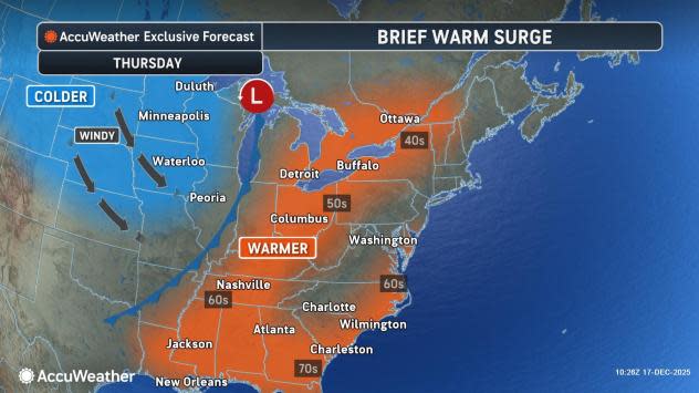
The pattern began with a surge of synoptic-driven warmth that pushed afternoon temperatures well into the 40s and low 50s from North Jersey through South Jersey. That brief warmup took a noticeable toll on existing snowpack, melting accumulated snow and leaving behind widespread runoff. As temperatures fall back into the 20s overnight, that melted snow is expected to refreeze, setting the stage for icy patches and prominent icicles by Thursday morning.
Thursday brings a temporary rebound above freezing during the day, but the bigger story arrives late Thursday night. A powerful storm system is forecast to move into the region, bringing widespread rain and increasing winds. Rain is expected to overspread New Jersey from west to east around midnight, becoming heavy at times through early Friday morning. Most areas should see steady rainfall until roughly mid-morning Friday, followed by a narrower band of precipitation before conditions improve.
Rainfall totals are projected to range from roughly three-quarters of an inch to over an inch in North Jersey, with somewhat lower totals across South Jersey. Alongside the rain, winds will become increasingly strong. Southerly and south-southwesterly winds will dominate ahead of the storm and during the heaviest rainfall overnight. As the system evolves early Friday, a brief but intense period of shifting winds could develop, particularly if a narrow convective band moves through. This window carries the potential for isolated thunderstorms and localized wind damage.
By late Friday morning, conditions will change rapidly as a cold front sweeps through the state. Winds will shift to the northwest and strengthen further, ushering in a much colder air mass. Temperatures are expected to drop sharply through Friday afternoon and evening. While this is not expected to meet flash-freeze criteria, the drop will be fast enough to refreeze standing water on untreated roads, sidewalks, and areas with poor drainage.
Compounding the risk is the fact that heavy rain will wash away road salt, increasing the likelihood of black ice Friday night into early Saturday. Drivers are urged to use caution, particularly on secondary roads that may appear wet but are actually frozen.
Looking ahead, attention is turning to the broader late-December pattern. Confidence is lower, but there is increasing interest in the potential for wintry weather around the Christmas holiday. A shifting jet stream pattern could place New Jersey near a sharp temperature boundary, meaning small changes could determine whether upcoming systems bring rain or snow. Several disturbances are being monitored between December 23 and New Year’s Eve, including the Christmas Eve and Christmas Day timeframe. While a white Christmas is far from guaranteed, the signal is stronger than it has been in recent years.
Saturday is expected to moderate somewhat after a cold Friday night, but another cold front is forecast to arrive Sunday night, returning the state to a colder pattern punctuated by brief warmups. This setup favors continued weather volatility through the end of the year.
In plain terms, New Jersey is entering a classic winter roller coaster. After brief warmth, the state will deal with heavy rain and strong winds late Thursday into Friday morning, followed by a rapid freeze and icy conditions Friday night. Temperatures rebound slightly over the weekend before colder air settles back in. Several potential systems could bring rain, ice, or snow as the holiday period unfolds.
For continued updates and in-depth coverage as conditions evolve, readers can follow Explore New Jersey’s Weather Report section, which will track changes and provide timely guidance as this active winter pattern develops.


