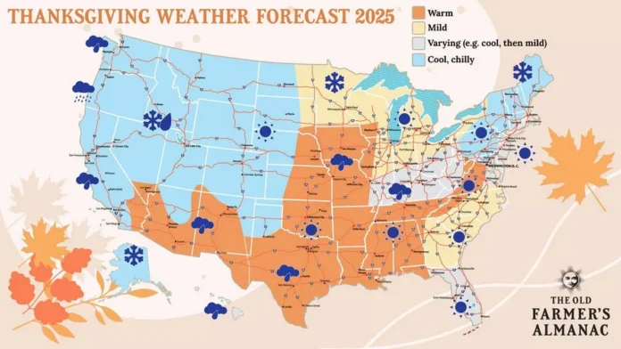
New Jersey is heading into one of the more dynamic stretches of late-November weather in recent years, with a powerful Great Lakes storm system, multiple cold fronts, lake-effect snow potential, and the early hints of a possible winter storm next week all converging at once. As we move through the holiday week, residents can expect a dramatic shift from unseasonably mild temperatures to a true taste of early winter. For continuing regional forecasting and storm updates, readers can follow our dedicated weather report coverage.
This week’s setup began with a deep low-pressure system, roughly 990 millibars, sweeping across the Great Lakes. Its warm front surged through New Jersey from south to north, briefly placing the entire state in a warm sector Wednesday afternoon. Temperatures reflected the surge: mid-50s in the northern elevations, mid-60s across central counties, and even close to 70 degrees along parts of coastal Cape May. That warmth, however, was never expected to last.
To the west, the system’s trailing cold front is now advancing toward New Jersey and will cross the state from west to east this evening into the overnight hours. As that front arrives, a quick burst of rain—possibly with an isolated rumble of thunder—may accompany it. Behind the front, colder and drier air will sweep in, sending temperatures downward through Thursday under brisk west-northwest winds.
Thanksgiving Day remains dry statewide, but the chill becomes far more noticeable. Gusty winds will make conditions feel even colder, setting the stage for a more significant drop Thursday night into Friday as a deeper pocket of cold air dips over the region. Friday’s highs may struggle to break 40 degrees across the northwest hills and stay below the mid-40s elsewhere. After a cold start in the 30s Friday morning, temperatures will fall quickly again after sunset.
With winds aligned directly from the Great Lakes toward New Jersey from Thursday night into Friday night, lake-effect snow bands will become active and persistent across upstate New York and northwestern Pennsylvania. A few of those narrow streamers may reach into northwest New Jersey, and a weaker band could even drift toward the I-95 corridor. Any snow that reaches the state should be light, mostly conversational flurries with minimal accumulation, except perhaps in the coldest pockets of Sussex and Warren counties where temperatures may briefly dip near freezing overnight.
The colder pattern holds through the weekend, but by Saturday and Sunday temperatures will begin a gradual rebound. The overnight lows between Friday and Sunday will be the coldest of the stretch, though pinpointing which morning will drop the lowest remains tricky as meteorologists weigh the competing influence of lingering cold-air advection versus radiational cooling under clearer skies.
The bigger question looming over the forecast is what unfolds early next week. On Monday, two separate atmospheric disturbances—one dropping out of the Arctic, another emerging from the Pacific—will begin to move toward the eastern United States. The timing of when these two pieces of energy merge is the key to whether New Jersey sees a legitimate winter storm on Tuesday or a more marginal cold-rain scenario.
If the coupling happens earlier and more aggressively, a significant snowfall becomes possible. If the merger occurs later or more weakly, the energy becomes stretched out, producing scattered showers with snow aloft but temperatures too warm near the surface for accumulation across most of the state. Seasonal climatology creates another challenge: average late-November highs near 50 degrees and ocean temperatures still in the upper 40s usually work against early-season snow along and southeast of I-95. Historically, it takes a robust storm to overcome these factors, though notable exceptions—such as December 2009, the December 2013 “Eagles Game” storm, and December 5, 2018—prove that it remains possible.
Major forecast models all detect some form of coastal development next week, though with differing intensities. The GFS remains the most enthusiastic about earlier energy consolidation, the European model the most hesitant, and the Canadian model sits between the two. More definitive clarity is expected by Friday, which will likely serve as the go-or-no-go day for meaningful snowfall potential.
Beyond the near term, longer-range indicators point toward an active and colder pattern through December into January. Key atmospheric signals such as the Madden-Julian Oscillation passing through phases historically supportive of East Coast snow, a weak La Niña pattern known for producing snowier winters, and a negative Quasi-Biennial Oscillation that promotes southward pushes of Arctic air all align in favor of an enhanced winter season. Should the Arctic Oscillation and North Atlantic Oscillation trend negative by mid-December, New Jersey could be looking at one of its most favorable setups for winter weather in years.
While no one is declaring a guaranteed white Christmas, the probability is higher than it has been in roughly a decade. For now, residents should prepare for a sharp holiday cool-down, keep a close eye on Tuesday’s evolving storm potential, and stay tuned as winter’s early signals begin to take shape across the Garden State.


