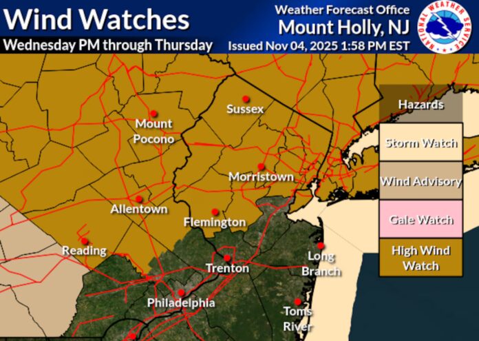
New Jersey is in for a blustery midweek stretch as a fast-moving upper-level disturbance brings gusty winds and a quick shot of rain late Wednesday into early Thursday. The system, a powerful shortwave sweeping across the Northeast, is expected to deepen a surface low-pressure center as it races through upstate New York and into New England — setting the stage for a windy night across the Garden State.
Unlike a full trough or low-pressure system, this shortwave packs just enough punch in the upper atmosphere to stir up strong surface winds and a sharp pressure gradient. As the system passes to the north, it will help pull a cold front across the region, tightening isobars and sending winds surging across much of northern and central New Jersey.
Throughout Wednesday, winds are expected to gradually increase from the west-southwest, strengthening as the day progresses. By mid-to-late evening, roughly between 8 p.m. and midnight, the winds should shift more northwesterly as the front crosses the state. This transition will mark the system’s passage — a brief period of scattered rain, followed by a rapid temperature drop and gusty post-frontal winds. While precipitation totals will likely remain light, with northern parts of the state seeing only a few hundredths of an inch of rainfall, the real story will be the wind.
Forecasters anticipate northwest wind gusts reaching 40 to 50 miles per hour across northern New Jersey, with isolated gusts topping 55 or even 60 mph possible in the higher elevations and more exposed areas. Central and southern portions of the state should also experience a breezy night, though gusts there are expected to stay in the 30–40 mph range. Outdoor furniture, decorations, and any loose yard items should be secured ahead of the strongest winds Wednesday night.
The National Weather Service has already issued high wind watches for many counties north and west of the New Jersey Turnpike. Motorists driving high-profile vehicles should use extra caution on open roadways, especially on bridges and elevated highways, where crosswinds may be more pronounced. Tree limbs weakened by recent weather could come down, and sporadic power outages are possible in a few spots.
Beyond the gusts, this system will also accelerate the seasonal transition visible across much of New Jersey. The winds will strip more of the remaining leaves from trees, especially in northern counties, leaving behind the late-autumn landscape that typically ushers in the colder weeks ahead. By Thursday morning, skies will clear quickly, temperatures will dip into the 40s, and humidity will drop — the telltale signs of drier air moving in behind the front.
The pattern remains active as we move deeper into November. Another round of unsettled weather is expected to develop over the weekend, leading into a more pronounced cool-down early next week. Forecasters suggest that a significant chill could settle across the state, potentially marking the season’s first widespread frost for interior areas.
With winds, temperature swings, and more changeable weather ahead, it’s another reminder that New Jersey’s fall season is far from over. For residents planning commutes, outdoor work, or weekend travel, staying updated on local forecasts will be key as the state moves from mild autumn afternoons into its first true taste of winter-like conditions.
For continuing coverage of New Jersey’s shifting weather patterns, regional updates, and local forecasts, visit Explore New Jersey’s Weather Report.


