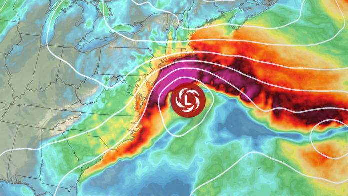
New Jersey is bracing for a major weather event this Columbus Day weekend as a powerful nor’easter tracks up the East Coast, threatening to deliver heavy rain, strong winds, and significant coastal flooding from Sunday, October 12 through Monday, October 13. Meteorologists warn that this storm could be the most severe coastal system to hit the Garden State since Superstorm Sandy in 2012, with the potential for widespread flooding, power outages, and dangerous surf conditions along the Jersey Shore.
The system, fueled by two merging low-pressure areas—one from the Great Lakes and another forming near Florida—is expected to intensify rapidly as it moves north. Once the two systems combine, the storm will stall near the Mid-Atlantic coast, locking New Jersey under a prolonged period of wind-driven rain, high tides, and pounding surf.
The National Weather Service has issued Coastal Flood Watches for nearly every shoreline county in New Jersey, including areas along the Delaware Bay. Forecasters predict a storm surge of two to four feet, enough to cause moderate to major tidal flooding, particularly during high tide cycles from Sunday night into Monday evening. Low-lying areas may see roads submerged and impassable, and emergency management officials are warning of the possibility of evacuations in the hardest-hit coastal towns.
Wind is also expected to be a major concern. High Wind Watches are in effect for the entire coastline, with gusts potentially reaching 60 miles per hour. Inland communities along the I-95 corridor could experience gusts between 30 and 50 miles per hour, strong enough to knock down trees, damage structures, and cause widespread power outages. With saturated ground and falling leaves, even moderate gusts could lead to downed branches and debris hazards on roadways.
Heavy rainfall will add another layer of concern. Although the storm’s rain will help alleviate ongoing drought conditions, the volume and intensity could quickly overwhelm drainage systems, especially when combined with coastal surge. Most of the state can expect 1 to 3 inches of rain, but areas near the shore could exceed 3 inches or more, particularly if the storm stalls offshore as expected. The heaviest rain will likely fall from Sunday morning through Monday afternoon, with intermittent lulls possible between intense downpours.
The storm’s impact won’t stop at the coastline. Beach erosion and dune breaches are expected along much of the Jersey Shore, as large waves and relentless surf batter the beaches throughout the weekend. Beachfront communities are being urged to secure outdoor furniture, signage, and decorations ahead of time.
As the storm intensifies, residents are encouraged to take immediate precautions. Those living in flood-prone or low-lying areas should move vehicles and valuables to higher ground, while homeowners should tie down loose outdoor items to prevent them from becoming airborne hazards. Power outages are likely, so it’s wise to charge electronic devices, prepare flashlights, and have backup batteries or generators ready.
Meteorologists anticipate that conditions will begin deteriorating late Saturday as clouds thicken and winds shift onshore. Rain will start off light and scattered but will become heavy and widespread overnight. By Sunday morning, the nor’easter will be in full force, bringing its strongest winds and heaviest rainfall through Monday afternoon before slowly tapering off.
Temperatures will also take a dip, with inland areas falling into the 30s and 40s overnight early in the weekend, adding a chill to already harsh conditions. Coastal residents should also be mindful of high tides between Sunday night and Monday night, which are expected to coincide with the storm’s peak intensity.
New Jersey emergency officials urge residents to monitor local weather forecasts and heed any evacuation orders if issued. Although the storm’s exact track could still shift slightly, the potential for major coastal flooding, high surf, and damaging winds remains high across the state.
For ongoing coverage, safety tips, and real-time updates on the nor’easter’s impact across the Garden State, visit Explore New Jersey’s Weather Report section.
As this powerful October storm bears down on New Jersey, the next few days will test the state’s coastal resilience and readiness. From the boardwalks of Cape May to the bays of Monmouth County, residents are being reminded that preparation today could make all the difference when the storm reaches its peak.


