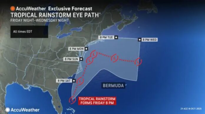
New Jersey is bracing for its first significant nor’easter of the season, set to arrive late this weekend and linger into early next week. While October often brings unpredictable coastal weather, this incoming system is shaping up to be one of the more impactful events in recent memory—particularly for communities along the shore.
The storm is expected to develop over the weekend and bring a combination of persistent rainfall, gusty winds, and coastal flooding that could reach major flood stages in certain areas. For those living near the coast or in flood-prone zones, preparation will be key.
A Quick Look at the Calm Before the Storm
The recent cold front that pushed through New Jersey has swept away the unseasonably warm and muggy air, leaving behind crisp autumn conditions. Overnight lows are expected to drop into the 40s across much of the state, with coastal areas staying slightly milder.
Thursday and Friday will bring the coolest weather of the fall so far, with daytime highs only reaching the low to mid-60s. Nighttime temperatures could dip low enough in parts of North Jersey—especially along and north of I-78 and I-287—for frost or even a light freeze. Expect clear skies and dry conditions both days.
Saturday brings a slight warm-up as winds shift from the ocean, bumping temperatures back up to around 70 degrees for many areas. But those mild temps will come with increasing cloud cover and a steady onshore breeze, setting the stage for the nor’easter to take hold.
Timeline of the Storm
The storm is forecast to arrive between late Saturday night and early Sunday morning, moving in from the south. Rain will start gradually and intensify through Sunday as onshore winds strengthen. Monday is expected to be the peak of the storm’s impact, with heavy rain, powerful wind gusts, and widespread flooding in low-lying coastal areas.
Conditions may not begin to noticeably improve until sometime Tuesday, depending on how long the storm lingers. If it stalls—as some models suggest—it could extend its impact well into the day.
For daily updates as the system approaches, you can track developments and local conditions by visiting the Explore New Jersey Weather Report section.
What to Expect: Rain, Wind, and Flooding
While rainfall totals will vary across the state, most areas can expect at least 0.5 to 1 inch of rain. South and Central Jersey, especially near the coast, could see 1 to 3 inches, depending on the storm’s track. Though the rain is welcome in drought-affected regions, its slow and steady arrival should allow most inland areas to manage the runoff.
Winds will be a more serious concern. Inland areas of North Jersey could experience sustained winds of 20–30 mph with gusts up to 40 mph, while coastal communities could see sustained winds between 25–40 mph with gusts as high as 60+ mph. These conditions are strong enough to bring down tree limbs, damage property, and cause scattered power outages.
Coastal flooding will likely be the biggest hazard. The persistent onshore flow—driven by a strong high-pressure system to the north and the storm’s cyclonic wind pattern—will create dangerous conditions along oceanfront areas, bays, and back creeks. Water levels may exceed moderate flood stages and could reach major flood levels in vulnerable spots.
Tides will also play a role, though there’s a bit of good news there. The moon is now past its full phase and currently waning, which should help ease the highest potential storm tides.
Preparedness Is Key
If you live in a coastal or flood-prone area—from the Jersey Shore to the Delaware Bay—now is the time to prepare. Charge devices, check backup power sources, secure outdoor furniture, and avoid driving through flooded roadways. Be especially cautious around areas with poor drainage, as even moderate rain can lead to street flooding during prolonged onshore flow.
If evacuation orders are issued by local officials, follow them promptly. For those staying put, stock up on essentials, keep emergency supplies handy, and plan for possible power disruptions. It’s a great weekend for comfort food, classic board games, and staying indoors.
Looking Ahead
The bigger picture shows a pattern that could usher in a more active coastal storm season this fall. While this nor’easter isn’t expected to break any records, it does serve as a seasonal wake-up call. After several quiet years, many New Jersey residents may be underestimating just how raw and disruptive these storms can be.
As we move deeper into October and the colder months approach, it’s important to stay informed and connected to reliable weather updates—not just for safety, but for peace of mind.
Keep following Explore New Jersey Weather Reports for updates, forecasts, and coverage throughout the storm.


