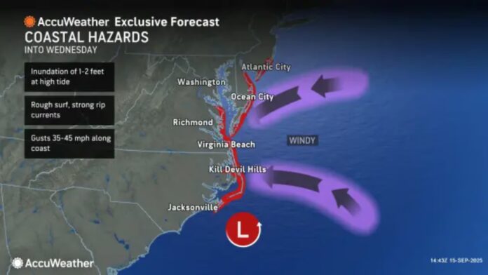
New Jersey is riding out another active stretch of late-September weather as a strong ridge over southeastern Canada interacts with a weak upper low drifting north from the Southeast United States. This atmospheric setup is pushing another coastal system toward the Garden State, echoing last week’s unsettled conditions. Residents can expect periods of rain, gusty winds, and minor coastal flooding, especially along the Jersey Shore from Ocean County down through Cape May. Eastern and southern coastal communities will once again shoulder the brunt of the storm, while inland areas remain less affected.
Humidity is the common theme this week—not the stifling stickiness of July, but enough to make afternoons feel muggy rather than crisp. By Friday, warmth and moisture will peak before a sharp cold front ushers in drier, cooler air just in time for the weekend. Early signs suggest a dramatic flip in conditions as September gives way to October, with the potential for one last surge of above-average temperatures followed quickly by the season’s first genuine chill.
The Forecast at a Glance
Monday, Sept. 15: Highs across much of New Jersey climbed toward 80 degrees, with coastal towns sitting closer to the mid-70s. Skies remained a mix of sun and clouds, with a hint of humidity. Light-to-breezy east-northeast winds were felt most strongly along the coast. Overnight lows dipped into the 50s across northern highlands and the low-to-mid 60s along southern shores, with a chance of isolated showers.
Tuesday, Sept. 16: Expect highs in the mid-70s statewide. While northwest New Jersey and inland communities should enjoy relatively calm conditions, the coast will turn unsettled as the approaching system spreads clouds and showers east to west. Winds will remain gusty for eastern and southern shores, with rough surf and hazardous rip currents developing. Overnight lows will sit between 55 and 65 degrees as rainfall spreads further inland.
Wednesday, Sept. 17: Cooler air settles in with highs near 70. This will be the storm’s peak impact day, bringing a mix of showers, wind, and the potential for a few thunderstorms. Northeasterly winds will keep surf conditions rough, and dangerous rip currents are likely along the shore. Inland, conditions will be noticeably milder. Overnight lows hover in the low-to-mid 60s as skies begin to clear.
Thursday, Sept. 18: Skies will slowly improve. The morning may begin damp and breezy, but by midday the coastal system retreats, allowing sunshine to return. Temperatures will rebound to the upper 70s inland and mid-70s along the shore, though humidity will linger as the sun breaks through. Surf conditions should gradually improve, but the ocean will remain active. Overnight lows again fall into the 55–65 degree range.
Friday, Sept. 19: The warmest day of the week, with highs well into the 80s and humidity holding strong, especially across central and southern coastal areas. Sunshine will dominate much of the day. By evening, however, a sweeping cold front will drop temperatures sharply, bringing overnight lows down into the 40s and 50s across the state and cutting the humidity.
Looking Ahead to the Weekend (Sept. 20–21): The weekend promises a true taste of fall. Highs may struggle to reach the 70s in parts of the state, with many areas likely stuck in the 60s. Saturday should feel refreshingly cool and dry, while Sunday could bring scattered showers along with continued autumn-like air. With this shift, Friday may prove to be the last widespread 80-degree day of September.
Meanwhile, in the tropics, Invest 92L has formed but is expected to curve well out to sea before reaching the latitude of the Lesser Antilles, sparing New Jersey from any direct impact. For now, the Atlantic remains quiet for East Coast interests.
As September winds down, residents should prepare for a transitional weather pattern—warm, humid days giving way to crisp, fall-like air. Whether you’re planning a weekend hike, a coastal visit, or simply commuting through shifting conditions, staying updated on the latest forecasts is essential. For more updates on shifting weather and regional conditions across the state, visit Explore New Jersey’s Weather Report section.


