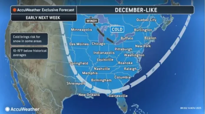
New Jersey residents can expect a mostly chilly pattern over the next week, with only a brief respite this Saturday before colder temperatures return. Meteorological analysis indicates persistent northwest upper-level flow across much of the state, with only a small break in this pattern on Saturday. Satellite and 500mb geopotential height assessments confirm this temporary mild period, with some locations in southern New Jersey potentially reaching near 60 degrees—the warmest temperatures in several weeks.
Friday featured highs in the low-to-mid 50s for much of the state, accompanied by mixed skies and the occasional isolated shower. Winds were light-to-breezy out of the west and northwest, and overnight lows dropped into the 30s and 40s, dipping below freezing in elevated areas of northwest New Jersey and some interior Pine Barrens locations in the south. Most residents remained dry, although pockets of rain were possible.
Saturday is expected to offer a brief warming trend, with highs ranging from the low 50s in northwest elevations to around 60 along southern coastal areas. The day should begin with a mix of sun and clouds, transitioning to mostly cloudy conditions by afternoon as rain approaches the evening hours. The window for precipitation is most likely between 7 p.m. Saturday and 7 a.m. Sunday, tapering off by mid-morning. Humidity levels will increase ahead of the rain, with overnight lows ranging from 45 to 55 degrees.
Sunday will mark the return of cooler, breezy conditions. Morning showers will give way to clearing skies by mid-to-late morning, and winds will shift to gusty northwest directions, signaling a return to the colder pattern. Highs are expected in the mid-to-upper 50s, with overnight lows dipping back into the 30s and 40s across the state.
Looking ahead to next week, the slightly colder pattern is likely to persist through Thursday, with highs generally in the mid-to-upper 40s in elevated northern and central areas and low-to-mid 50s elsewhere. Overnight temperatures will hover in the 30s and 40s. By late November, a milder stretch is forecast, coinciding with the Thanksgiving holiday period. However, early indications suggest December could arrive with a significant cold snap, potentially ushering in snow and early winter conditions across New Jersey.
Meteorologists point to several indicators supporting this early winter onset. Westerly winds in the equatorial stratosphere, a weak La Niña pattern, and the return of the negative North Atlantic Oscillation (NAO) could allow Arctic air to penetrate southern latitudes. Additionally, a Sudden Stratospheric Warming Event (SSWE) expected near the North Pole around November 30 may displace the polar vortex southward, amplifying cold air flow into the eastern United States by mid-December. These factors suggest that New Jersey may see an early winter with colder-than-normal temperatures and increased snow potential.
For residents preparing for the upcoming week, Saturday offers the last opportunity to enjoy milder conditions before the chill returns. Rain is expected in the evening hours, but dry, breezy conditions will dominate Sunday and much of the week to follow. As always, staying updated with reliable weather reports can help New Jerseyans plan outdoor activities and prepare for rapid shifts in temperature and precipitation.


