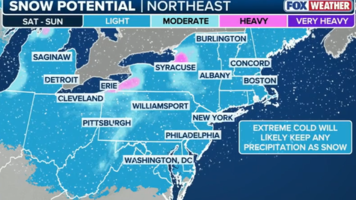
New Jersey’s first meaningful snowfall of the season is increasingly likely, as a complex series of atmospheric features set the stage for a light-to-moderate winter storm late Saturday night into Sunday morning. Forecasters are monitoring a dynamic setup in the upper levels of the atmosphere that could deliver a statewide, plowable snow event—one driven not by a classic coastal storm, but by a flatter, fast-moving disturbance riding a sharp temperature gradient from the Midwest into the Mid-Atlantic.
The current jet stream pattern is locked in a west-to-east orientation from Montana across the Midwest and directly into the Mid-Atlantic, a configuration that limits major storm development but supports moisture-bearing waves that can squeeze out precipitation with little warning. A surface high sitting beneath a shortwave trough is expected to help drag moisture across this corridor and toward the coast. As the wave approaches, a strong Arctic high dives out of Canada, reshaping the flow into a more amplified pattern over the weekend. This temporary shift encourages a weak ridge to form in the western U.S. and a positively tilted trough over the East—conditions favorable for a small coastal low to develop off the Delmarva or Outer Banks late Saturday night.
These ingredients, though subtle, can combine to produce a surprisingly efficient snowfall event. The forming offshore low, enhanced jet streak support, and the strong thermal gradient marching across New Jersey all point toward accumulating snow beginning around midnight Saturday and lasting through roughly 10 a.m. Sunday. Even modest forcing in a cold environment can yield higher-ratio snowfall, meaning totals may exceed what would typically be expected from a low-end system.
Signs of that colder air already appeared Thursday, when lake-effect streamers briefly swept across South Jersey from Philadelphia to Atlantic City. The state settles under a noticeably colder air mass through Friday and Saturday, with highs in the mid-to-upper 30s along the coastal plain and areas northwest of I-95 struggling to climb above freezing. By Saturday night, temperatures tumble quickly as the wave approaches. All major atmospheric layers—925mb, 850mb, and 700mb—are projected to remain well below freezing, a key indicator that any precipitation will fall as snow, even in shoreline communities typically vulnerable to marine influence.
Right now, forecasters expect accumulating snowfall throughout New Jersey, with the potential for a broad 2–4 inch event, including isolated areas exceeding that range. The exact placement of the heaviest banding remains uncertain. If the wave tracks slightly north, southern parts of the state may struggle to cool sufficiently at the surface. If it slides south, northern counties may miss the best forcing. But if the wave aligns with the core of the cold air and jet streak enhancement, a more substantial stripe of moderate snowfall could develop across central and southern New Jersey.
The window for accumulation—midnight through mid-morning Sunday—could feature several hours of steady snow, with pockets of moderate intensity possible if a developing coastal low or stronger jet dynamics materialize. While the system is not expected to be a major winter storm, it has enough potential to produce plowable totals, slick roadways through Sunday morning, and the kind of seasonal backdrop perfect for holiday lights and hot chocolate by Sunday evening.
As meteorologists refine the track and snowfall bands, New Jersey residents can expect updated projections, including the season’s first detailed snow map, on Friday. For continuing coverage of regional conditions, Explore New Jersey’s weather report section will have updated information as the weekend approaches.
Snow lovers have reason to be optimistic, and for much of New Jersey, the season’s first meaningful accumulation appears increasingly within reach.


