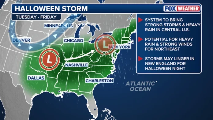
The large trough forming over the eastern United States is bringing dramatic shifts to our regional weather, but the good news for New Jersey is that tropical systems will stay well offshore. While some earlier projections hinted that Tropical Storm Melissa could interact with the trough and potentially steer closer to the coast, steering currents in the Atlantic are now keeping it on a safe path — tracking northeastward from the Bahamas toward Bermuda and out into the open Atlantic. That means the Garden State can breathe easier, with no threat of a tropical landfall.
The current system that will affect New Jersey this week has a completely different origin. A new area of low pressure is developing across western Tennessee and is expected to dip south toward Georgia and the Carolinas before curling back north into Pennsylvania. This type of track — often called an “inland cutter” — keeps New Jersey on the warmer side of the storm rather than the coastal cold side where nor’easters typically form. In other words, this is not a nor’easter.
The setup involves a complex mix of atmospheric dynamics: a negatively tilted trough, upper-level divergence, and a developing jet streak are combining to generate rapid cyclogenesis over the southeastern U.S. As that system matures, it will send a shield of rain and gusty winds northeastward into the Mid-Atlantic.
For New Jersey, rainfall is expected to move in late Wednesday night, gradually spreading from southwest to northeast. While a few scattered showers may appear earlier in the evening, the steadier and heavier rain will arrive overnight and continue through much of Thursday. By the Thursday morning commute, most of the state will be seeing moderate to heavy rainfall that should persist well into the day.
Rain will taper off from southwest to northeast late Thursday night into early Friday morning. Most areas can expect between 0.75 and 1.5 inches of rainfall, though localized downpours could easily push totals above 2 inches, and a few spots may even flirt with 3 inches depending on where the heaviest bands form. Regardless of exact totals, a widespread soaking rain is on the way, so commuters should plan for reduced visibility and ponding on roads.
Winds will also be a factor. Gusts will begin increasing late Wednesday night, peak during the day Thursday, and remain strong into Friday as the system intensifies while lifting northward into New England. Inland areas can expect gusts between 25 and 35 mph, while coastal regions could see bursts up to 45 mph, perhaps slightly stronger in exposed spots. Once the rain ends, winds will shift from a southerly direction to the west and northwest as colder, drier air moves in behind the front. By Friday, with the low pressure system deepening below 990mb over northern New England, widespread gusts between 30 and 50 mph will be possible across the state.
For those already preparing for Halloween festivities, there’s some good news. The rain will be long gone by the time trick-or-treaters head out Friday evening. However, the brisk winds and falling temperatures will be noticeable. Expect a chilly, blustery Halloween night, so if you’re heading out, plan for layers and secure any lightweight decorations. Kids should avoid costumes that can easily catch the wind.
After the storm passes, a stretch of drier weather will settle in for the weekend. Cooler air behind the front will drop temperatures and accelerate leaf fall across the state — great news for those enjoying autumn color, but not so much for early leaf cleanup efforts. If you’re planning yard work, you may want to wait until later in the weekend once winds calm down and the final round of leaves hits the ground.
For ongoing coverage of changing conditions, including wind advisories, temperature drops, and more detailed local forecasts, visit our Weather Report section. The upcoming days will bring classic late-October volatility — from soaking rain to brisk, blustery skies — marking a dramatic seasonal shift as New Jersey heads into November.


