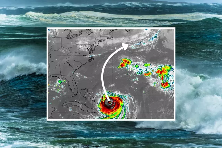
As Hurricane Erin churns through the Atlantic, it’s important to separate fact from fiction. Despite some alarming posts circulating online, Erin will not make landfall in New Jersey or anywhere along the U.S. East Coast. That means no direct strike, no catastrophic winds, and no destructive storm surge here in the Garden State.
Instead, New Jersey will experience secondary impacts — lingering showers, breezy conditions, rough surf, and a temporary uptick in humidity — as the storm expands offshore. Let’s break down what residents can expect over the coming days.
Erin’s Track: Safely Offshore
Erin is currently positioned just north of the Bahamas and has begun shifting from a westward path to a northwest track. A high-pressure ridge over the Southeast U.S. and another ridge near Bermuda are essentially guiding the storm into open waters.
By midweek, Erin’s center is forecast to pass between Bermuda and the Outer Banks of North Carolina, then curve northeast back out into the Atlantic. From there, it will move south of New England before tracking farther out to sea.
For New Jersey, this means no landfall and no direct hit — just fringe effects as Erin’s wind and rain field expands while it undergoes extra-tropical transition.
This Week’s Weather in New Jersey
The overall theme for the week is cooler, cloudier, breezier conditions with scattered showers:
- Tuesday – Friday morning: Expect on-and-off showers, occasional gusty winds, and higher-than-usual humidity.
- Temperatures: Most days will stay in the 70s, with Friday potentially creeping just above 80°F.
- Humidity: Comfortable dew points will briefly take a backseat, but relief returns by the weekend.
Once Erin pushes farther out to sea by Friday and Saturday, we’ll see a shift to lower humidity, cooler nights, and clearer skies.
Coastal Impacts to Watch
Even though Erin will remain offshore, the storm’s wide circulation means the Jersey Shore will feel secondary effects:
- Rough surf & rip currents – Waves will build throughout the week, creating dangerous conditions for swimmers.
- Beach erosion – Persistent onshore flow could reshape parts of the shoreline.
- Minor to moderate coastal flooding – High tides may bring localized flooding, especially in low-lying areas.
For surfers, these conditions could provide world-class waves, though choppy weather may make conditions less ideal. For swimmers, however, the risk is serious. Lifeguards are urging beachgoers to respect rip current warnings and stay out of unsafe waters.
The Big Picture: No Panic, Just Precaution
The bottom line: Erin is not a direct threat to New Jersey, but it will be felt indirectly through unsettled weather and hazardous marine conditions. Think of this week as a fringe tropical brush — clouds, showers, some breeziness, and dangerous surf — before a refreshing late-week cooldown.
This pattern is also a reminder that hurricane season is ramping up. Tropical waves continue to emerge off Africa’s west coast, meaning more systems could develop in the coming weeks.
In Summary
- No Landfall: Erin will pass offshore and will not strike New Jersey or the East Coast.
- Weather This Week: Cloudy, breezy, showery, highs in the 70s. Humidity sticks around until Friday.
- Coastal Impacts: Rough surf, rip currents, beach erosion, and minor flooding possible.
- Weekend Outlook: Lower humidity, cooler temps, and clearer skies once Erin moves away.
For the latest local weather coverage and storm updates, head over to our Weather Report section.


