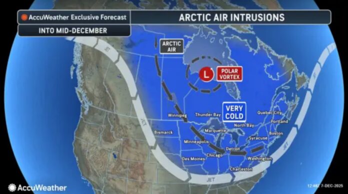
New Jersey is starting the week under the firm grip of an Arctic front that has swept into the region, dropping temperatures sharply and ushering in some of the coldest air of the season. From the northern corners of Sussex County to the coastal stretches of Monmouth and Atlantic, residents are waking up to biting winds, stinging cold, and the unmistakable feel of deep winter settling in. The kind of cold that hits hard, lingers, and reminds everyone that January in the Garden State doesn’t play around. For the latest statewide updates and regional conditions, readers can check our weather report coverage.
The coldest punch arrives between Monday and Tuesday as the Arctic air mass reaches full force. Afternoon highs early in the week barely sneak into the low 30s, but the temperature alone tells only part of the story. Steady gusts between 25 and 35 mph are dragging wind chills down into the teens, and in some northern and inland communities, it feels like the single digits. Even brief trips outdoors carry that sharp, numbing edge that sends people searching for scarves, gloves, and any excuse to stay indoors.
Tonight is expected to deliver the most intense cold of the stretch. Overnight lows will fall deep into the teens across much of the state, and isolated spots could slip into single-digit territory. The combination of clear skies, Arctic air, and persistent winds will make for a raw and unforgiving night from the Delaware River to the Jersey Shore. Heating systems will be working overtime, and residents are encouraged to check on elderly neighbors, bring pets indoors, and shield pipes wherever possible.
Tuesday won’t bring much relief, with high temperatures stuck in the mid-30s and winds remaining strong enough to keep the air feeling much colder. It’s the type of weather pattern that settles in and refuses to budge, testing commutes, straining infrastructure, and making those morning cup-of-coffee runs feel like Arctic expeditions.
A modest change arrives midweek as a passing system shifts temperatures just enough to break the deep freeze. Wednesday brings a brief reprieve, with highs climbing into the mid-40s. Rain is likely, and in northern New Jersey, the setup may lead to a mixed bag of rain and snow. While it won’t be a full thaw, it should ease the severity of the cold and melt accumulated frost on windshields and walkways.
The break is short-lived, however. By Thursday and Friday, colder air presses back into the state. While not as harsh as the early-week chill, highs will settle back into the upper 30s, signaling a return to a below-normal pattern.
Looking beyond the workweek, meteorologists expect a persistently chilly stretch to continue into the weekend and potentially beyond. The overall setup favors additional bursts of cold air and a few opportunities for light snow. The current Arctic blast may weaken midweek, but the larger pattern shows New Jersey locked firmly into a wintry rhythm. Residents can expect plenty of layering, scraping windshields, and watching for quick changes in storm tracks during commutes and travel plans.


