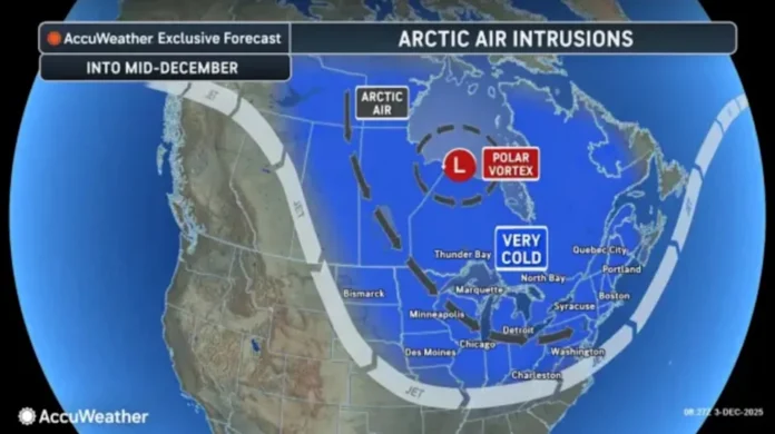
New Jersey is gearing up for a dramatic shift in weather this week, with a surge of Arctic air set to sweep through the state and usher in a prolonged stretch of cold. According to early indicators, a strong cold front—powered by a burst of polar vortex energy—will charge across the region Thursday afternoon into the evening. As part of Explore New Jersey’s [weather report] coverage, this incoming pattern signals the start of what could be an active and noticeably colder stretch heading into mid-December.
This front is more than your average early-winter cooldown. Meteorologists point to recent atmospheric activity, specifically the Sudden Stratospheric Warming Event (SSWE) that occurred in late November, as a driving factor. SSWEs typically take one to two weeks to influence weather at the surface, and New Jersey is now entering that window. The result is a potent and sustained flow of cold air plunging from the Arctic straight into the U.S. Northeast—what some are calling a “cold train” of back-to-back systems expected to dominate the region from this Friday through at least mid-month.
Temperatures will take a noticeable plunge once Thursday’s front pushes through. Friday is shaping up to be the coldest day of the season so far, with some parts of the state likely stuck in the 20s for daytime highs. Bitter wind chills are also expected, giving the Garden State its first true taste of deep winter.
The next question is what comes after the front, and that’s where the forecast becomes more complicated. Forecasters are tracking a weak disturbance that will cross the Midwest and slide into the Mid-Atlantic between Friday night and Saturday morning. The challenge lies in determining how far north this system’s precipitation shield will reach.
Model guidance remains split. The European model suggests that light snow could make it into Central and South Jersey, enough for a dusting or light accumulation if conditions line up. Meanwhile, other major models—including the GFS, NAM, and Canadian—keep the system suppressed to the south, missing the state entirely. This discrepancy highlights the fragile balance of timing, moisture, and track that often determines early-season snowfall.
Interestingly, while Tuesday’s earlier system was too warm statewide to produce widespread snow, this weekend’s setup presents the opposite issue: it may be too cold for ideal snow production if the storm is forced too far south. If the jet stream dips too sharply, the storm’s moisture may bypass New Jersey altogether.
Still, with another SSWE forecast to develop in the coming days, the broader trend suggests more cold shots are likely as December progresses, with the potential for more robust wintry systems later in the month and even into January.
For now, New Jerseyans should prepare for an abrupt temperature drop, a frigid Friday, and the possibility—though uncertain—of a light snow event for parts of the state early Saturday. Winter is arriving quickly and decisively, and this week’s pattern marks the beginning of what could be a very active season across the Garden State.


