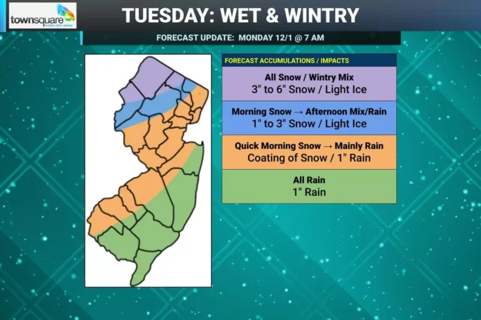
As the first full week of December begins, New Jersey is bracing for a Tuesday winter system that is shaping up as a mixed precipitation event, with snow focused primarily in northwest and northern parts of the state. Meteorologists are tracking a complex low-pressure system advancing from the Great Lakes region and into the Eastern Seaboard, bringing with it a combination of Pacific and Gulf moisture streams. Residents can stay updated on ongoing conditions through our weather report coverage.
The storm’s energy originates from a Pacific system that crossed the northwestern United States and is now being funneled toward New Jersey via a cold front linked to a low near Toronto. This system is expected to move eastward, passing through New Jersey later Tuesday. Ahead of the cold front, a warm front is pushing northward, keeping temperatures along the coastal plain in the 40s to 50 degrees. Northwest elevations, however, remain near freezing, and light snow accumulation has already been observed early Tuesday.
For much of southern and central New Jersey, the storm will mostly manifest as a rain event. The combination of ocean influence and warmer daytime temperatures will prevent snow from sticking in areas south and east of the I-95/NJ Turnpike corridor. Even in northern central regions up to the I-78/I-287 line, any early snow is likely to be minimal and may briefly mix with sleet before transitioning fully to rain.
Northwest New Jersey and northern regions, however, are expected to see the most significant snow accumulation. With colder overnight temperatures setting the stage, snow is likely to stick once precipitation intensifies Tuesday morning. Areas along and north of I-80 and west of I-287 are forecast to receive the highest totals, with snow continuing through mid-to-late morning and into the early afternoon before tapering off by sunset. Surface temperatures are expected to remain low enough to preserve accumulation throughout the day in these zones.
Timing for the precipitation is expected to begin in the pre-dawn hours Tuesday, gradually increasing in intensity through the morning and peaking during mid-morning to early afternoon. The storm should exit the state by Tuesday evening, leaving the majority of northwest New Jersey with a winter landscape while other areas transition back to rain or mixed precipitation.
Despite the cold start and early snow in the northern elevations, the storm is not anticipated to disrupt daily life across most of the state. Schools and businesses in southern and central New Jersey will likely experience only minor impacts, as snow accumulation will be minimal and precipitation is expected to remain above freezing for much of the day. The system is largely an early-season preview rather than a full-scale winter shutdown.
The pattern sets the tone for a brisk start to December, with temperatures dropping back below freezing statewide Tuesday night and keeping the door open for additional wintry signals expected around December 5-6. This early-season activity highlights how quickly the snow season can begin in northwest and northern elevations, even as southern and coastal regions see mostly rain events initially. Residents should monitor local updates, especially in higher elevations, for changing snow totals and travel advisories throughout the day.
With this system, New Jersey is reminded that winter weather is already making its presence felt. For continuous coverage and the latest advisories, explore our weather report section, which provides detailed updates on precipitation, road conditions, and forecasts for the coming weeks.


