New Jersey’s recent rainstorm has officially ended, delivering much-needed precipitation across the state. Every region saw at least 0.75 inches of rainfall, with western parts of the state just reaching that baseline. Eastern New Jersey, particularly in the northeastern counties, saw rainfall totals exceed 2 inches, and some localized areas recorded between 2.5 and 3 inches. While the rain was a welcome relief for dry areas, its timing coincided with a brief onshore flow near high tide yesterday, resulting in moderate coastal flooding in select shoreline communities. Thankfully, that flooding has now subsided, and offshore winds will help lower tide levels moving forward.
Attention now turns to the wind. As predicted in earlier updates, this storm is producing its strongest gusts after the rain has passed rather than during it. Coastal regions experienced winds from the south and southeast at 35-45 mph during the rainfall, but now, with the cold front fully through, winds are shifting out of the northwest. A consolidating low-pressure system, now centered over the northeastern United States at 982mb and continuing to deepen, is driving these gusts. The temporary lull between yesterday evening and early this morning gave way to tightening isobars aligned for a W/NW wind flow, signaling that stiff winds will persist today and into tomorrow morning. Along with the blustery conditions, temperatures and humidity are dropping, ushering in a colder, drier air mass.
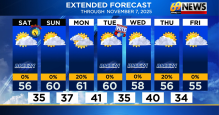
Halloween night will be chilly and windy but dry, offering a safe environment for trick-or-treaters if dressed appropriately. Winds are expected to gradually subside by late Saturday morning, allowing the weekend to remain rain-free. Highs for both Saturday and Sunday are likely to stay in the 50s statewide, with coastal regions cooling into the 40s overnight. Inland areas and northern New Jersey, particularly in elevated regions, could see temperatures dip into the 30s. Most inland areas should remain above freezing, though northwestern elevations may flirt with 32°F or slightly below. This shift signals a transition into late-fall conditions, with cooler temperatures and increasingly bare trees following peak foliage.
Looking ahead, the next system of interest is expected around November 4th. Early tracking suggests a synoptic setup that could bring rain but is unlikely to produce significant snow at lower elevations, though higher terrain could see colder conditions.
Tonight’s forecast emphasizes caution for Halloween festivities. Parents should ensure that young children are dressed warmly and securely, as gusty winds may make the evening feel even colder. No rainfall is expected, so outdoor celebrations will remain dry, though the wind will persist into the overnight hours and early Saturday morning. By late Saturday, winds will diminish, giving way to a crisp, fall weekend.
For updates on New Jersey weather and to track storm developments, visit Explore New Jersey Weather Report for continuous coverage.
With the storm behind us, the state transitions into cooler, wind-swept conditions, bringing the first real taste of late fall before winter approaches. Residents should prepare for chilly evenings, particularly along the coast and in elevated northern areas, while enjoying a dry, brisk weekend ahead.


